Khao Yai was the first National Park created in Thailand. It covers an area of 2,168 square kilometres of forest and grassland and together with some surrounding protected areas form the Dong Phayayen-Khao Yai Forest Complex World Heritage Site which provides habitat for another impressive array of wild creatures.
The morning mist, the splendour of the scenery, the certainty of seeing at least some of the wildlife and the fact that it’s just a three hour drive from the outskirts of Bangkok ensure that it is a well visited park. Weekends and holidays are best avoided, but if you have an interest in wildlife a visit at some stage is an absolute must. The Rockjumper birding tour I was on spent two full days in the park. Longer would be better, wouldn’t it always. If you are visiting independently here are a couple of resources that might help, thainationalparks.com and thaibirding.com.
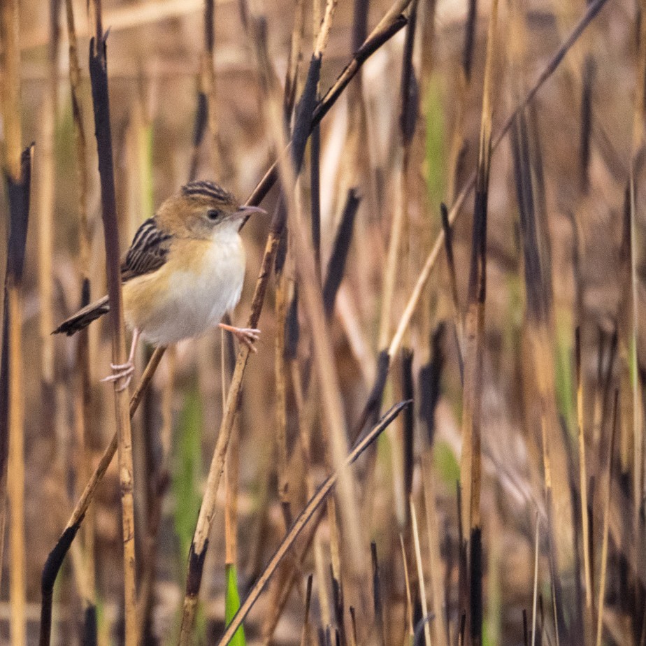
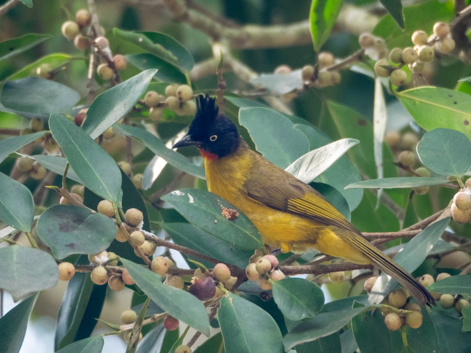
Birding highlights included Silver Pheasant, Blue and Eared Pitta, Vernal Hanging Parrot, various Barbets, Woodpeckers, nightjars and the Collared Owlet. A few birds were happy to pose …
Mammals that we encountered included Black Giant and Variable Squirrels, Muntjac and Sambar Deer. The Sambar are unphased by the photographer’s close approach.
Sambar
Pig-tailed Macaques are a certainty, Gibbons much less so. There are two species present – Pileated, which we heard and White-handed which we were lucky enough to see.
White-handed Gibbon
This guy was accompanied by his wife and baby. The females are brown, the babies, of course, are adorable.
No matter how big you are a few metres into the forest and you’re virtually invisible. Last time I was on foot this close to an elephant I was running for my life (and Asian Elephants deserve the same respect that African ones do). However half a dozen people had already walked past it without it showing any sign of irritation and, in the forest, I was virtually invisible too … I hoped.
A long day in the bus. The Thais drive on the left, just like we do in Oz, how sensible of them.
Our transport consisted of two absolutely luxurious minibuses. More importantly, they were driven by the nicest chauffeurs you could ever hope to meet. Tiang and June, as well as getting us efficiently around the place, twice a day they would set up a circle of chairs and provide us with our 11 am little lunch and afternoon tea. Served with a big smile, sometimes even with chocolate. Nice people.
We took a little detour back to the salt flats, the Nordmann’s Greenshank was unfinished business. It took two stops to find a flock of them. The Spoonbilled Sandpiper is a super sexy bird, I have even seen it featured on tee-shirts, I doubt that the greenshank will ever be so honoured. To be sure that you are looking at one, not a Common Greenshank, you need to observe its two tone bill, and note that its legs are slightly shorter. It has but one saving grace – it’s rare! Tick.
Next stop was a duck pond at Bangtaboom. Here we found a plain white stork and a few other water birds. Quite a drab stork really. If it wasn’t so hideously rare it would hardly be worth looking for. Milky Stork, tick.
We skirted Bangkok, stop start, stop start and continued eastwards. As dusk approached we made a very brief stop at Sabkaret Reseach Station to say hi to the Siamese Fireback. It’s a very attractive Pheasant. It could grace a tee-shirt, no trouble.
We arrived at our accommodation after dark.
The best birding is early morning. Breakfast was early, we would be on our way before dawn. It was a feature of the entire tour that we almost never saw our accommodation in daylight.
We saw the sunrise in Sab Sadao. This is an area of dry deciduous woodland a habitat that is uncommon in Thailand and more like parts of Cambodia which isn’t all that far away. And that explains why we were there, a different habitat brings a new suite of birds. Memorable among them was the Red-breasted Parakeet.
We also saw a couple of other sights that stick in the memory. A ute came past taking some kids to school. There were half a dozen girls in the tray. There was a canopy over that and half a dozen boys perched on top of that. And then there was this …
Cock fighting is legal in Thailand. Good fighting birds change hands for huge sums of money and fortunes are gambled on the outcomes of contests. These birds are merely training, the spurs on their legs are bandaged to prevent injury. In fact, the spurs are often covered in competition as well. In Thailand it is not the custom to fit blades on the feet.
Next stop was a wetland at Lam Pra Elerng. Whilst we were watching the water birds some Brown-backed Needletails swept through. I was commenting that in Oz, Needletails, in our case White-throated Needletails, generally travel with storm fronts when the rain started. Moments later I was wetter than the ducks in front of me.
Thailand’s largest national park covering an area of 2914 km² and just part of an even larger forest that extends west into Myanmar and north and south in Thailand. According to the Thai National Parks web page it is home to at least 420 species of bird, 57 mammals and about 300 species of butterfly.
Looking west into Myanmar
Just to conjure with some delicious possibilities, Tiger, Leopard, Asian Elephant, White-handed Gibbon and Great Hornbill are all here, although you might not want to meet all of them on a dark road. The possibility exists … there are three campsites!
The Great Hornbill has to be the signature bird, it may measure as much as 122 cm from tip of bill to tip of tail, that’s almost exactly 4 feet in the old money. Its wing beats can often be heard before the bird is seen. It’s a hole nester and therefore needs a lot of forest with a lot of very big, very old trees. It’s why places like Kaeng Krachan are so very precious.
That’s right, my photo was lousy but it inspired me to have a go with the crayons.
Spent three days here and divided the time between different elevations. The birding was excellent.For me the hornbills were the stars of the show, besides Great there were also Oriental Pied, Wreathed and Tickell’s Brown. Hanging Parrots, Barbets and especially the odd Trogon threw in some colour …
Orange-breasted Trogon
Occasionally the watchers were themselves under scrutiny …
Dusky Langur
Other primates we encountered were Banded Langurs and Stump-tailed Macaques. White-handed Gibbons were often heard calling but stayed out of sight.
Some of the 300 butterflies were about. I would be grateful to anyone who can identify this one, just drop me a comment …
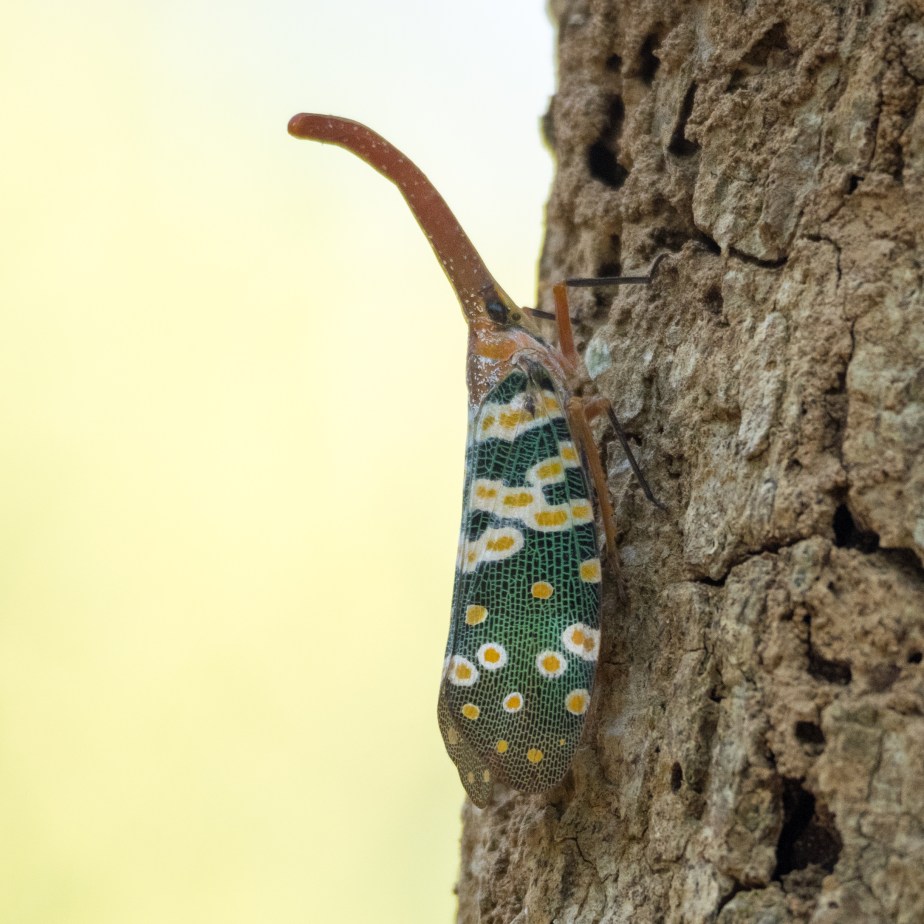
Even large creatures can be hard to find in a dense forest, there was plenty of evidence of elephant but neither they or the tigers put in an appearance. But I am not prejudiced against smaller things …
Lantern bug
I have a reasonable faith in my identification of this little beauty as Pyrops candelaria. In the distant past it was thought that they emitted light from their proboscis. Sadly, this is not true.
And my chances of identifying a Skink aren’t especially great but this is probably Dasia olivacea in a confiding mood …
Olive Dasia
Three days amassed a good bird list but in many ways just scratched the surface. I would love to go back.
The serious birdwatcher should check out Nick Upton’s page for some great information on how to get the best from their visit or book through Rockjumper.
Following my walk in the park it was back to the Maruay Gardens Hotel to meet the group I would be traveling with and our guides Uthai Treesucon, Thai ornithologist extraordinaire, and Keith Valentine, managing director of Rockjumper Birding Tours. I will mark their report cards later.
The tour began on the morrow with a drive to Pak Thale and its world famous salt works. This is located about 125 km southwest of Bangkok on the shores of the Gulf of Thailand.
This area is one of the best places anywhere to see the shorebirds of the Asian Flyway. They mostly breed way to the north and escape the winter by long migration to warmer climes. Top of our list of desirable species were Spoon-billed Sandpiper and Nordmann’s Greenshank.
We amassed a list of 43 species (not all shorebirds) including the Spoonie but not including the Greenshank.
Fair views were had of the Spoon-billed Sandpiper but I got nowhere near close enough to get a good photo. I pinched this one from arkive.org who are keen to conserve the creature and would be pleased if you dropped by their website, especially if you made a donation. The one in the picture is in breeding plumage, in winter they lack the colour. The easiest way to pick them out of a hoard of little waders is to look for the characteristic side to side feeding motion of their heads, very similar to the much bigger and not closely related Spoonbills, convergence of form and function, I suspect.
The upside of group travel is that accommodation, transport and local knowledge are all in the package. The downside is the little time available to sit and wait for that magic photo. Snatch what you can …
Marsh Sandpiper
Once finished in the salt pans it was on to the Laem Phak Bia sandspit. To get there we took a boat not unlike the one below down a mangrove lined creek out to the sea, making a wet landing on the spit.
Note the engine mounted onboard with the propeller on a long shaft. This seems to be the standard arrangement in Thailand. It enables operation in shallow water and provides good maneuverability.
Our main objectives were Chinese Egret, Malaysian Plover and the enigmatic White-faced Plover, currently a distinctive subspecies of Kentish Plover but may one day be elevated to full species status. We found them all and a few terns and shorebirds as well.
From there it was back into the minibus and on to Kaeng Krachan, Thailand’s largest national park.
My Rockjumper cap had arrived in the mail before leaving Australia. I put it on as I stepped into the outside world from the sequestered realm of Customs and Immigration. This, I hoped would improve my chances of finding my limo driver.
Bangkok is a sprawling traffic jam imprisoning some 11 million souls. Skyscrapers of concrete and glass reach up, entwined by tollways, overpasses and bridges. New roads are being built on stilts over old roads desperately trying to keep up with the needs of a populace who all just bought a nice new car. As the Rough Guide puts it …
… under the shadow of the skyscrapers you’ll find a heady mix of chaos and refinement, of frenetic markets, snail’s-pace traffic jams and hushed golden temples, of dispiriting, zombie-like sex shows and early-morning alms-giving ceremonies.
It was early morning when I arrived at the Maruay Gardens Hotel. Way too early to check in but they were kind enough to store my luggage and let me use the wifi. Good old Google Maps showed a park not too far away although the receptionist thought my chances of finding a whole load of birds there were pretty low. I took a taxi to Chatuchak Park, joggerland.
There were a lot of people but I felt really, really special as the only one carrying binoculars …
but, hey, it was worth it. There were birds, mammals, reptiles, trees, grass and a lake. It was a gentle introduction to the birds of Thailand with all day to figure out what they were …
Black-collared StarlingSmall MinivetOriental Magpie Robin
I managed to identify 18 species of bird, a couple more slipped through to the wicket keeper. Some Squirrels were happy to pose and a couple of reptiles were about although one was the introduced Red-eared Slider. I was far more impressed with this one, especially when it began stalking some pigeons …
It was a Rock Jumper birding tour and therefore a pretty hardcore, monomaniacal trip but if your eyes are open for birds and your mind isn’t closed to all else you get to see quite a lot.
Thailand sits in the centre of the Indochinese peninsula, it is in the northern hemisphere and entirely within the tropics. It has a land area of 513,120 square kilometres (198,120 sq mi), and a population of about 66 million people. The landform is essentially that of a large bowl, a central fertile and mainly flat region embraced by mountains to the west, north and east. The Malay peninsula juts out to the south separating the Gulf of Thailand from the Andaman Sea.
You can find an interactive map and regional information at Rough Guides, not a bad place to start if your interests are more main stream than mine!
In broad outline there are three seasons to the year. Mid May to mid October is rainy because of the south-west monsoon. This is followed by the north-east monsoon, allegedly this is winter, characterised by milder temperatures and, for most of the country, less rainfall. This lasts until mid February when summer begins. The result for most of the country is a Tropical Savanna climate, the Malay peninsula is considerably wetter and warmer, the mountains considerably cooler. Summer temperatures commonly range up to 40°C, outbreaks of cold air from China can bring winter temperatures down to zero.
My visit lasted three weeks and took me to all points of the compass, to the top of Doi Inthanon at 2,565 metres (8,415 ft) and the Pakthale saltworks at sea level. I got to look a wild Asian Elephant in the eye, see Gibbons swing past at close range and encounter 490 species of bird. It was a very successful trip.
Thailand is a very complex place, presently a military dictatorship with a constitutional style monarchy. As you drive around it has some of the look and feel of other parts of tropical Asia but it is clearly more affluent than say Vietnam. Modern industrial buildings sit alongside beautiful Buddhist temples, apartment blocks and modern houses alongside bamboo shelters and market stalls. Pictures of the former king are everywhere, on billboards, public offices and private enterprises large and small. The present king not quite so much but that may change once the period of mourning for his father ends in October.
The other day in Bangkok someone detonated a pipe bomb causing several people to suffer ringing in the ears. It’s not that long ago that tear gas was required to keep the Red Shirts and Yellow Shirts apart, but as a visitor the impression is of a modern, orderly and safe society.
The road from Birdsville south to Marree is the famous Birdsville Track.
When the railway reached what was then Herrgott Springs (now Marree) in 1883 the graziers of the channel country of western Queensland and the south-eastern corner of the Northern Territory had the option of a shorter route to market. The biggest obstacle facing them was about 500 km of desert from the Diamantina River to the rail head. This is seriously dry country, average rainfall is less than 100 mm a year (4 inches). But the Great Artesian Basin lies beneath and by 1916 bores had been sunk every 40 km.
Tom Kruse was the legendary mailman who took the mail and other supplies up the track to the good citizens of Birdsville. A classic film was made about his work in 1954 called “The Back of Beyond“. This played a large part in giving the track a certain reputation which wasn’t improved by a disaster that befell the Page family. They set out from Marree just days before Christmas in 1963 with the object of finding work in Queensland. Their car ran out of petrol, the result of a navigational error combined with gearbox problems that kept them stuck in 2nd gear. At that stage they were fairly close to a windmill and turkey dam. They were able to fill a four gallon drum with water and carry it back to the car.
Two days later they set off on foot and were found dead on January 1st 1964. Their abandoned car, with a radiator full of water, not far from the turkey dam, had been found on the 28th of December. There was a tarpaulin on the trailer that could have been used for shade. Mum, Dad and three kids were buried beneath the Coolibah where they were found.
The track, although still unsealed, has largely been tamed for routine tourist use but it’s still just as bloody hot out there. Take plenty of water, a satellite phone (or HF Radio) and if your vehicle lets you down stay with it.
Ironically, the thing that is most likely to immobilise you on the track is rain.
We were among the first to escape from Birdsville when the track reopened. It was still in very muddy condition, deeply rutted and in places quite slippery. We passed a number of stranded caravans and a truck that had been taking consumables to the impending race meeting. It was an interesting morning.
In places it was much muddier than this but it would have been unwise to stop for a photo …
It was our intention to camp at Mungerannie (if you want to sound cool remember that despite the following E, the G is hard like the G in manGo, and it’s got double n unlike the spelling in the map that I filched from Wikipedia ) but the place was very busy as traffic coming up from the south and been unable to get any further. It certainly seemed unlikely that caravans would be travelling on for a few days yet. After a welcome beer we pressed on to Cooper Creek and had a pleasant night under the coolibahs where conversation turned to the fate of previous travellers who had camped on the Cooper. Anyone for some more of this delicious nardoo?
photo – TLG
The following morning saw us meeting the locals …
Western Brown (photo TLG)Brolga with chicks
… checking out more of the ruins of Goyder deniers …
Lake Harry
… and soon we reached Marree closing the loop.
The rest of the journey was essentially a repeat of the ride up, only quicker because we were now a little behind schedule.
I have compared crossing the desert to scuba diving. I can’t breathe underwater or find water in the desert but I can strap some tanks on my back and dive or fill a vehicle with the essentials and drive. Birdsville is like a little boat, you can surface and relax, resupply with food, refuel the vehicle, rejoin the life of modern Australia. During the time that this little boat has been anchored here the divers surfacing have changed from drovers to drivers.
Birdsville sits between the channel country and the Simpson. The nearest dune is currently invading the cemetery just the other side of the airstrip, the Diamantina River is 4km from town when it’s behaving itself. It comes to visit occasionally. The main road runs north south.
Way over to the west is Mr Stuart’s road, the main road from Adelaide to Darwin, it towed the telegraph and the railway behind it. Birdsville lies on the Burke and Wills road. What came after them were more explorers trying to find where they’d gone. This is the losers’ side of the desert. For the graziers of the channel country there was a major market off to the south. The principal reason for a road was as a stock route. And at the time the stock route came into being Queensland and South Australia were colonies. Starting in about 1878, Birdsville grew up at the intersection of the road, a river and the colony boundary. It is adjacent to the best spot to cross the Diamantina, often a place occasioning some delay. Where better for a store to resupply the drovers and a border post where import duties could be collected. When the railhead reached Marree in 1883 things really kicked along. In 1900 it had three pubs (droving is thirsty work) and a population of about 300 people. Australian Federation happened in 1901, this brought free trade between what were now states. So the tolls were abolished and the population steadily declined.
In the 1950s the population was down to about fifty.
Birdsville, it seemed was consigned to history. In the cemetery you can find the graves of Wankangaru aborigines born in the desert, white settlers, drovers and Afghan cameleers, whilst the legend of Tom Kruse the man who brought mail and supplies up the 500 km Birdsville Track lives on. The history is rich.
The races are an enduring tradition in Birdsville. They were first run in 1881. The crowds are far bigger now than there were then. The rise of the 4WD vehicle has put Birdsville back on the map. People come from all over to visit Australia’s most isolated town, the population now might be about 100 souls, but on race day expect to see at least 7 000 other people.
The little boat is now anchored here to supply the tourist. There is only one pub these days but you can buy a beer at the bakery! Driving is thirsty work.
Birdsville can be very hard to leave …
… we had to wait three days before we could. It gave us time to take in the sights …
the Bakery … sleepy hollow until the races then unimaginable bedlam. Not only can you get a beer here, Curried Camel Pie figures on the menu. We all found an excuse not to try one, mine was vegetarianism. After breakfast a quick walk to the Royal Hotel, built in 1883 last drinks were served in 1923 when it was converted to a hospital which it remained until 1937.
Other essential stops include the Roadhouse and the Visitor Centre.The bird watching around Birdsville is excellent. Between the town and the Diamantina there is the famous billabong, sadly the track to Pelican Point was underwater, not that that bothered the Pelicans. Nor did it bother the Caspian Terns, Kites, Red-backed Kingfishers, Woodswallows in several flavours or Spoonbills …
Black-faced Woodswallow (photo – TLG)
Royal Spoonbill
The race track is out this way as well. Heavy just about summed it up …
photo – TLG
That’s not the river on the other side of the fence, that’s the track.
Birdsville’s drinking water comes straight out of the ground. The bore is 1280 meters deep and delivers water at 98ºC. The heat isn’t wasted, it’s used to drive Australia’s only Utility Company owned geothermal power station with an output of 80kW meeting about a third of the town’s electricity needs. Surplus water runs off to the billabong to keep the ducks happy, whilst the rest is stored aloft in reservoirs that look stunningly beautiful for several minutes every day …
And by the time you’ve finished the Cook’s tour you’re ready for a drink at one of my favourite Aussie Pubs … the Birdsville Hotel …
We had crossed the Simpson Desert. I would do it again at the drop of a hat. It was right up there with any place I have ever been.
Is it for you?
Yes it is … provided you can tick these boxes :-
You have a reliable high clearance 4WD vehicle and some experience using it
A companion vehicle
Maps
Satellite phone (or HF Radio)
Dune Flag
Shovel
Winch
Radio
Snatch strap
Fuel
Water
Food and
A sense of humour
I hope to see you out there but I have a favour to ask. UTFR.
This stands for Use The Radio.
I have a pilots licence and a Marine Radio Operators Licence, I have absolutely no fear of public speaking. Give me the radio and I will give you a lecture. It’s easy for me. If you find it daunting remember they can’t see you … that’s the whole point.
On the track you will hear chatter between vehicles. Some of it is so inane you will wonder what on earth the speakers have between their ears. But you will know they are there. They are on the same one lane track as you and they may be coming toward you on the other side of the very next dune. Say hi, say where you are and which way you’re going, express an interest in where they are and which way they’re going. Don’t be shy. And if they ask, please reply.
Big Red
Some people do it really well. I use this photo again because you see a little convoy on the right of the picture. From the top of the dune they had broadcast this …
Convoy of three vehicles departing Big Red, west bound, now.
Thank you party of three, safe journey.
Channel 10 is the channel to use in the Simpson.
The technology is not perfect. UHF is essentially line of sight and dunes do interfere with reception. If the aerial set up is different between stations it is possible that you may hear them but for them to be unable to hear you. So a dune flag and a sharp lookout are also essential. Motor bikes are not required to fly a flag and are unlikely to be using radio.
Big Red is 40 km west of Birdsville, about 30 metres high and famed in legend and song. It is the focus of an annual concert and a car rally. Many a 4WD wannabe takes the run out there from Birdsville to try out their truck. Coming from the west it is, by some counts, dune number 1113. You first see the top of it over this ridge …
One dune away …
and when you get closer it looks like this …
Big Red
On that particular day the tracks on the left ended with steep churned up sections, the tracks further right were easier. The place to celebrate is on top …