Thought for fuel …

The last thing you need on a holiday is anxiety.

If you plan well then the trip is likely to go well. If  you have considered what might go wrong and you have a strategy ready it may not seem so bad if it happens.

How much fuel will you need to cross the Simpson?

Oodnadatta to Birdsville via the French Line measured on the odometer was 640 km. We had reckoned on 750 km for the trip to Mungerannie via the Warburton Track. You need to factor in the effect of low speeds, low gear and slipping tyres. You also need to allow for side trips and diversions.

We had a petrol and a diesel vehicle in our little convoy. This meant we couldn’t share our reserve fuel but it also meant that we could compare the two. We set off from the Pink Roadhouse with full tanks plus 40 litres each in jerry cans. There was no need for anxiety regarding fuel. Both vehicles arrived in Birdsville more than half full.

Usage …

  • Toyota FJ Cruiser                        petrol    108 litres     = 17 litres/100km
  • Toyota Landcruiser series 70    diesel      82 litres     = 13 litres/100km

The difference in economy is nowhere near as great on the open road. Diesel is clearly better in the desert. (But I still love my Cruiser.)

We transferred the reserve as soon as we reasonably could. Corrugated roads are hard on containers, the last thing you need is your reserve fuel leaking into the sand.

UTFR …

We had crossed the Simpson Desert. I would do it again at the drop of a hat. It was right up there with any place I have ever been.

Is it for you?

Yes it is … provided you can tick these boxes :-

  • You have a reliable high clearance 4WD vehicle and some experience using it
  • A companion vehicle
  • Maps
  • Satellite phone (or HF Radio)
  • Dune Flag
  • Shovel
  • Winch
  • Radio
  • Snatch strap
  • Fuel
  • Water
  • Food and
  • A sense of humour

I hope to see you out there but I have a favour to ask. UTFR.

This stands for Use The Radio.

I have a pilots licence and a Marine Radio Operators Licence, I have absolutely no fear of public speaking. Give me the radio and I will give you a lecture. It’s easy for me. If you find it daunting remember they can’t see you … that’s the whole point.

On the track you will hear chatter between vehicles. Some of it is so inane you will wonder what on earth the speakers have between their ears. But you will know they are there. They are on the same one lane track as you and they may be coming toward you on the other side of the very next dune. Say hi, say where you are and which way you’re going, express an interest in where they are and which way they’re going. Don’t be shy. And if they ask, please reply.

Big Red
Big Red

Some people do it really well. I use this photo again because you see a little convoy on the right of the picture. From the top of the dune they had broadcast this …

Convoy of three vehicles departing Big Red, west bound, now.

Thank you party of three, safe journey.

Channel 10 is the channel to use in the Simpson.

The technology is not perfect. UHF is essentially line of sight and dunes do interfere with reception. If the aerial set up is different between stations it is possible that you may hear them but for them to be unable to hear you. So a dune flag and a sharp lookout are also essential. Motor bikes are not required to fly a flag and are unlikely to be using radio.

Love to hear from you.

Big Red …

Big Red is 40 km west of Birdsville, about 30 metres high and famed in legend and song. It is the focus of an annual concert and a car rally. Many a 4WD wannabe takes the run out there from Birdsville  to try out their truck. Coming from the west it is, by some counts, dune number 1113.  You first see the top of it over this ridge …

One dune away ...
One dune away …

and when you get closer it looks like this …

Big Red
Big Red

On that particular day the tracks on the left ended with steep churned up sections, the tracks further right were easier. The place to celebrate is on top …

McGee on the Real McCoy

and then 40 klicks further on …

p1100577

It was just another dune.

Eyre Creek …

There was a bit of a breeze and the next rain band wasn’t expected until the evening. There was nothing to gain by rushing off, better to let things dry out a little. We took the time to enjoy the locals enjoying their new lake …

photo- TLG
Crimson Chat (photo- TLG )

And we took our opportunity to smell the Gidgee Trees. I found them not as bad as their reputation. Their leaves though are poisonous to stock (and presumably people, don’t eat the Gidgee).

When we got to Eyre Creek there was practically no water in it. When it floods it’s because of heavy rain over a much wider area and the result can be a river up to 30 km wide that can take months to subside. That’s not to say there was no challenge, the flood plain was a quagmire especially on the western side. So we slipped and slid with many a sideways moment for several kilometres. We were thrilled to be on the eastern bank …

TLG

Big Red here we come …


A change in the weather …

There was a magnificent sunrise and no ice on the cars. Cloud had kept some warmth in.

We packed up and drove up the west side of Lake Poeppel, crossing the salt encrusted surface near the northern end. Light rain settled the dust.

Having made our northing we headed east along the QAA line towards the Queensland border. One desert but three states and three different regulatory authorities. In South Australia we’d travelled through the Witjira National Park and then a Regional Reserve, in the Northern Territory we appeared to be on vacant Crown Land. At the Queensland Border we entered the Munga-Thirri National Park.

The QAA line is initially similar to the French Line, rolling dunes. The dunes are quite high and the swales quite broad often with a clay surface. The amount of vegetation seemed to be slowly declining.

We had a decision to make regarding our camp site. Beyond Munga-Thirri lies Adria Station. After leaving the National Park there would be nowhere to camp until Eyre Creek. Off to our north-east lie the three major rivers of the channel country, the Georgina, Diamantina and Cooper. Georgina joins with Burke and Hamilton to become the Eyre Creek, this is the driest of the three. Some years water flows down these channels into Lake Eyre, some years there is no flow at all. When we set off we knew that the Warburton was flooded and that Eyre Creek was dry.

lake_eyre_basin_map

We could smell the impending rain. The big question was would it be enough to bring us to a halt? There were three options

  • a mad dash for Birdsville
  • a longish day to the far side of Eyre Creek
  • short drive, camp in the park

One of the highlights of the trip was still ahead of us, the most famous dune in the universe – Big Red. We had no wish to rush this. The mad dash was rejected.

A camp in the park would be on sand. Wet sand is absolute luxury compared to mud. The black soil along the creek would only be fit for hippos after just a couple of millimeters of rain. And surely there would only be a couple of millimeters, big rain events are usually summer phenomena …

We camped just inside the park.

One of the locals was also happy to smell the roses ..

bobmcgee.live

By evening it was cold and raining heavily. Overnight there was a very impressive thunderstorm. My guesstimate is we had 25 mm of rain. We piled out of our tents in the morning to a landscape full of little lakes.

bobmcgee.live

photo -TLG
photo -TLG

We got the weather forecast by satellite phone. They’re was much more to come and the Eyre Creek flood plain ahead of us. This was going to be interesting.


Turning the corner …

Towards the eastern end of the French Line the dunes get higher and further apart. The swales are more likely to be clay and salt lakes make their appearance. This is Lake Tamblyn, named by Colson after his school teacher.

L Tamblyn

Before long we reached the intersection with the Knolls Track where there is even more obvious evidence of change … trees.

Gidgee

These are Gidgee trees, Acacia cambagei, said to emit an offensive odour when wet, variously described as like boiled cabbage or town gas. The weather this day was fine but we would have our chance to savour the smell before the trip was over.

At the intersection there is a rough and ready plaque celebrating the efforts of the surveyor David Lindsay who passed this way in January 1886. These days he would be fined up to $1000, the nanny state closes the desert for the summer.

Our next landmark was Poeppel Corner. Once just like any other spot in the desert but now a magnet because it is the entirely artificial place where South Australia, Queensland and the Northern Territory collide. Mal and Kelly and sundry others had preceded us and left an indication of their IQ …

Poeppel woz ereJust imagine, you could chip a golf ball from South Australia, through the Territory to a hole in Queensland and someone has been kind enough to provide the opportunity … but you need to be a left-hander.

photo TLG
photo TLG

Whilst there are three main routes across the desert they are by this stage reunited for the last push to Birdsville. To avoid a crowded campsite we took ourselves to the western side of Lake Poeppel for the night. Sunrises are so much better in the Northern Territory …

LP Sunrise

The French Line …

We had come here to enjoy the desert not conquer it. We’d knocked off the 1900 km to Hamilton in four days, an average of 475 km a day. For the next six days we would average just 88 km a day. This would keep us driving for as much as four hours a day but give us plenty of time to stop for anything that sparked our interest.

French Line

The desert was carpeted in wild flowers. I was surprised at how densely vegetated it was. Birds and reptiles were well represented but we saw little in the way of mammals. There were plenty of camel tracks and some camel droppings … by the way, these look like horse shit designed by a committee. To that can be added one House Mouse and a dingo.

For all its awesome reputation driving the French Line west to east presented no great challenge. Concentration was required, you needed just enough momentum to ease you over the crest, too much would rearrange the contents of the vehicle unnecessarily. There was often a moment when all you could see was the bonnet and the sky. When the road came back into view it wasn’t guaranteed to be straight ahead.

The dunes trend SSE-NNW and continue parallel for many kilometres, some as much as 200 km unbroken. This pattern is seen throughout the deserts of Australia. The height and spacing between the ridges have an inverse relationship. Where there are 5-6 ridges in a kilometer, the height is around 15 meters. Where there are one or two ridges per kilometer the height jumps to 35–38 meters. Dunes on the west of the desert are mostly small but they increase in size as you head east. The eastern faces are not only steeper, they are also longer. (No you don’t get further and further below sea level, you climb quite gently across the interdune space before reaching the next challenge.) Where dunes are close together the surface in between mostly remains sandy but where they are widely spaced the surface is often clay – much more of a challenge than sand when wet.

In places the track is scalloped, this effect is blamed on the drivers who fail to lower their tyre pressure and those who insist on towing camper trailers although I think injudicious use of the brakes on the downhills is just as much to blame. On steep faces the scallops are out of phase, your left wheels go in as your right wheels come out, it feels like riding a camel. On lesser slopes they are side by side. Either way the wave length is the average length of a vehicle.

During the second night a cold front passed through. It brought no rain but the wind drove sand into everything. I woke with sand in my sleeping bag, even some between my teeth.


Regal Birdflower
Regal Birdflower
Fleshy Groundsel
Fleshy Groundsel
Central Blue Tongue
Central Blue Tongue
Central Netted Dragon

The desert has a stark beauty. Visiting is a little like scuba diving … we don’t have the means to live there but we can take what we need to enjoy it for a short time and come away looking forward to the next time.

Moon rise over the saltbush
A full moon rises over the saltbush.

Sand …

To see a World in a Grain of Sand
And a Heaven in a Wild Flower 
Hold Infinity in the palm of your hand 
And Eternity in an hour
                                      … William Blake

The road beyond Dalhousie Springs had not been graded and had a challenge for every season, clay pans for the wet, dunes for the dry and stones to puncture the tyres at any time at all. The corrugations were ferocious – we were carrying hard-boiled eggs that were actually peeled for us by the vibrations. Vehicle contents were redistributed freely – note to self, screw top lids are a really good idea. They would have saved scooping up the sugar off the floor of the car.

At Purni Bore it all changes. No more stones, corrugations become far less arduous. This is the start of the sandy desert. Time to drop the tyre pressures to 18 – 20 psi.

Purni Bore
Purni Bore

Soon we leave Witjira National Park and enter the Simpson Desert Regional Reserve. Before long we are cresting the first dune on the French Line. The first of many, you could count them, but be aware, if you get confused tradition dictates that you go back to the beginning and start over.

Intersection

Camping restrictions are eased. We can now camp anywhere within 50 metres of the road.

Desert Camp

by Night


Witjira …

The map below gives you an idea of the possible routes through the desert. If you click on it it will enlarge sufficiently to be readable, the back arrow on your browser will bring you back here. Study it for a while, I’ll ask questions shortly …

SD Map

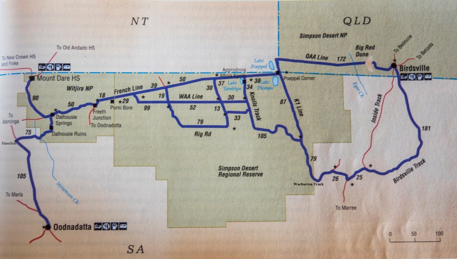
You do need a Desert Parks Pass to enter the South Australian section of the Simpson, when you buy that you will also receive some better maps but they don’t photograph well.

Our route was as straight forward as it gets, north from Oodnadatta to Hamilton, north-east to Dalhousie, east along the French Line, Poeppels Corner, north to join the QAA Line, east to Birdsville. Just a simple matter of cresting more than a thousand dunes.

The sand doesn’t actually start until Purni Bore. The road from Hamilton to Dalhousie Springs had been graded since the last rains. This was a pleasant surprise because we knew it had been cut up badly not long ago and we expected difficult going. There was just one spot where we needed 4WD, a wet creek crossing with muddy approach and departure.

After a while we entered Witjira National Park which once was the Dalhousie Station and before long we came to the ruins of the homestead …

Dalhousie

Dalhousie

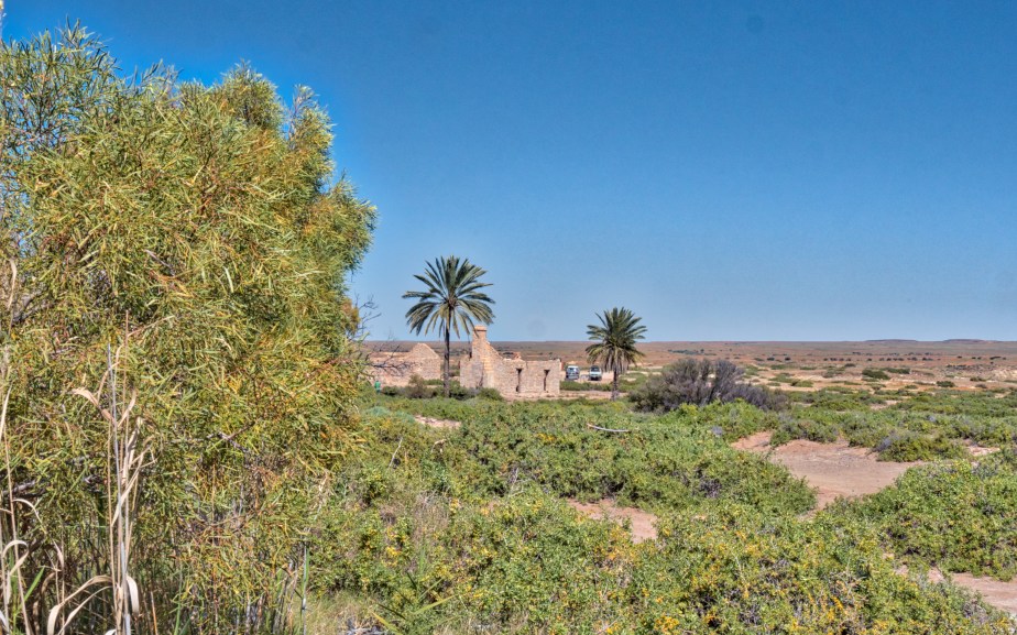
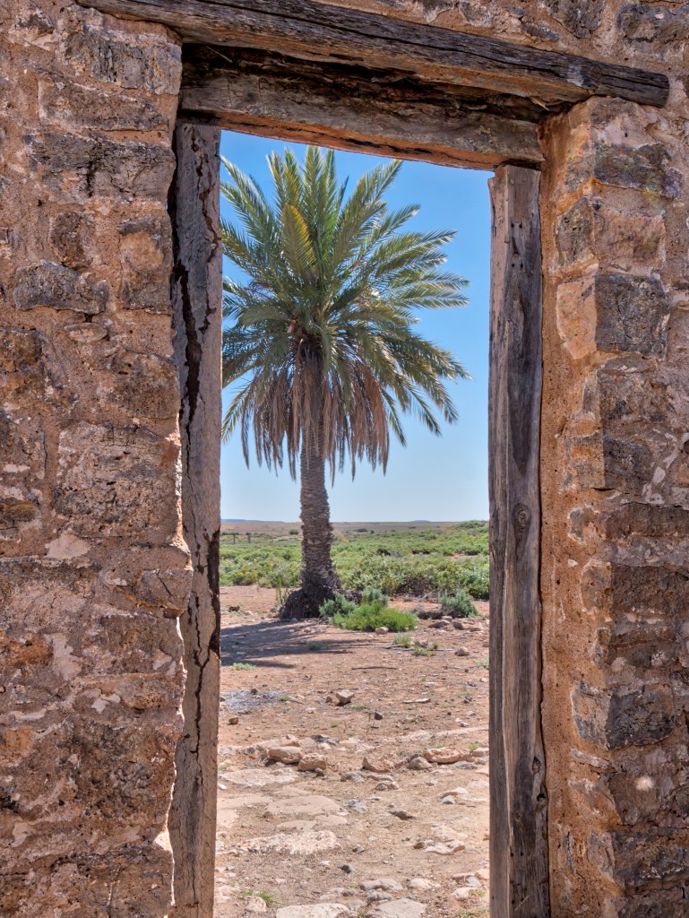
The Dalhousie lease was granted to the Bagots in 1873, the home stead is situated adjacent to a reliable mound spring. Date palms were introduced very early in the piece and thrived on the springs to the detriment of everything that belonged there. The Parks service have removed all but a few male specimens.

We made a fairly short day of it and camped at Dalhousie Springs. This is another collection of mound springs, one of the resulting pools makes a splendid swimming hole, as large as  an Olympic swimming pool, about two metres deep and warm. It even has steps to help you in and out. There are some nice walks that take you through the Melaleuca woodlands supported by the springs and there are plenty of birds.

This Singing Honeyeater is just a juvenile which is evident from the yellow gape. Its parents were still feeding it but it did pick up food for itself as well. The name, Singing, was obviously bestowed by someone with rose-tinted hearing aids.

SiH

The arid zone seems an odd place for a cormorant, but this Little Pied Cormorant was perched above the swimming hole on the look out for a Dalhousie Goby or any of the other fish endemic to the region.

LiPdCormt

A dingo visited us shortly after sunset. We had heard them on previous occasions but this was the first one to show itself.

The campsite itself though is bleak and the population density is considerably higher than where you live (even if you come from Tokyo). The toilets are suitable for anyone with a working in confined spaces ticket and breathing apparatus. I would suggest tying a rope around your middle so that a safety observer can pull you out should you not emerge within a few minutes.

There are only three sites where you can camp in Witjira. The next site on our route being Purni Bore. Older accounts wax lyrical about the birding at Purni but the bore has been capped and it no longer seems all that exciting. It may have been better to go slightly out of our way and camp at Three O’Clock Creek, just stopping for a walk and a swim at Dalhousie on our way through.

Next time …

This is where we fitted our vehicles with their dune flags. The last thing you need on the crest of a dune is a surprise encounter with a vehicle headed in the opposite direction. The flags are visible before the front bumper.

Time as well to switch the radio to UHF channel 10. Chatter between other vehicles is often the only indication that you are not alone although occasionally someone has the wit to let the world know where they are and which way they are going.


Desert fringe …

At Oodnadatta we filled our fuel tanks.  Just as they reached the point where they could take no more we crept up behind the vehicles with a brick in each hand and clapped them together on the differentials …

We needed to travel about 650 km to the next fuel, we also wanted the option of taking any detour that might be necessary or desirable. Both the FJ Cruiser and the Landcruiser will do about 1200 km of country road on full tanks but we anticipated higher consumption in the days ahead. We took an extra 40 litres for each vehicle in Jerry cans.

We also topped up our water supply which we carried in a number of containers, we had already had one rub through because of corrugated roads – beer cans, too, needed careful scrutiny and emergency consumption at the first sign of deterioration. We travelled on with five days regular supplies plus a week’s reserve.

Just north of Oodnadatta we parted with the main road which goes on to Marla. Instead we headed to Hamilton Station where they have a very fine campsite about a kilometre off the road. We had up to this point been putting in big days of driving now it was time to smell the roses …

Sturt's Desert Pea
Sturt’s Desert Pea
Acacia sp.
Acacia sp. (?murrayana)

The dunes surrounding the camp were alive with wild flowers and the birding along the Hamilton River, on this occasion a series of pools, was excellent.

Zebra Finch
Zebra Finch
Crested Pigeon
Crested Pigeon