Well, yes, that was the objective …


I was particularly keen to see how the falls would look when light painted. So I tucked into some sandwiches and waited for the light to fade. What do you think?


and pray that there's intelligent life somewhere out in space
Well, yes, that was the objective …
I was particularly keen to see how the falls would look when light painted. So I tucked into some sandwiches and waited for the light to fade. What do you think?
The Grampians National Park is one of Victoria’s jewels.
If you think of the Great Dividing Range as starting in north Queensland, sweeping south inland of Australia’s east coast and around the bend into Victoria the Grampians is where it makes its last desperate attempt to be mountainous. And a very scenic effort it is.
It and Wilson’s Promontory are the two Victorian parks under the greatest visitor pressure. At peak season the crowds are really bad, but don’t expect to feel lonely the rest of the year.
It has given Parks Victoria every opportunity to indulge itself in regulations, warning signs, railings and outrageous penalties. The rock climbing fraternity are the latest victims.
For a photographer who likes to use a drone as one of his cameras the frustration is immense. Drones cannot be flown without written permission on any Parks Vic property no matter how remote or lonely. Which locks away most of the great landscapes in the state.
Nonetheless it’s still worth a visit. My intention was to do some waterfall photography but I also felt the need for some exercise so I got there early with a view to climbing Mount William, the highest point. Although there was nothing on the Park’s website I found the Mount William Road closed. My 4 km hard hike had turned into a 24km hike, I wasn’t that early.

I settled instead for a ramble up to the Pinnacle via the Grand Canyon and Silent Street a 4.2km return hike from the Wonderland car park. There are plenty of excuses available to the photographer to rest along the way.


The view from the top is heavily polluted with man made constructions but with careful placement of the camera, towns, dam walls, railings, signs and tourists can all be avoided.
From there it was off to Mackenzie Falls for the late afternoon light.

Swimming, of course, is forbidden.
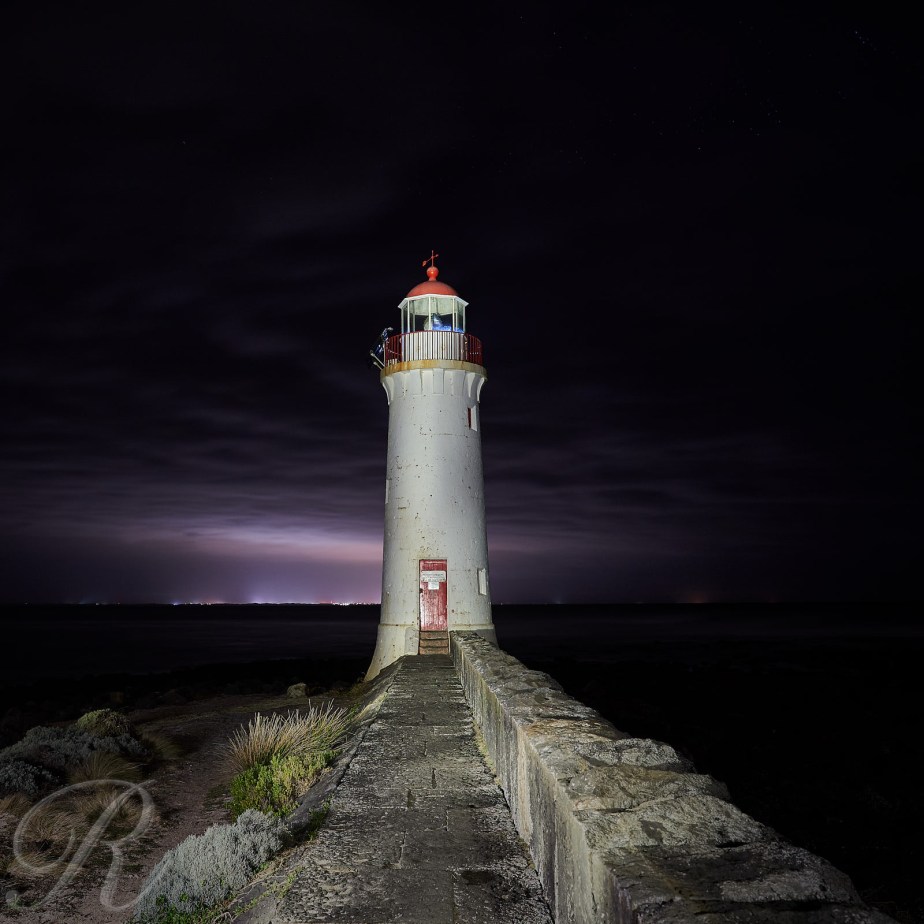
Captain John Hart saw Cape Nelson off to starboard and set his course for Adelaide. It was March 30th 1837 he was sailing from Launceston, Van Dieman’s land (known since 1856 as Tasmania) to Adelaide in the three masted barque Isabella with a cargo of livestock and the Pearce family as passengers.
Not long after that the Isabella was wrecked. She ran into the real Cape Nelson. Captain Hart had misidentified Lady Julia Percy Island.
Twenty five passengers and crew took to the boats and made it safely to Portland which had been settled about three years earlier, the first town in what would become Victoria. I doubt the livestock fared as well.
It’s a wild and woolly spot now guarded by a lighthouse.

The following afternoon the cloud cleared …
Which meant another trip to the lighthouse …

Then to bed. To sleep and dream until 3.00AM for this was the peak of the Eta Aquariid meteor storm. This is debris from Halley’s Comet. This little time lapse was shot in Victoria’s Western District from about 4am until just before dawn. The sky is at it’s most frenetic just as Venus comes up behind the gum tree.
So it’s new moon and I’m at the coast. The Night Augmented Reality module of Photopills shows the milky way emblazoned across the night sky with the lighthouse beneath. All that stands between me and a photogasm is a dense layer of cloud. The lights of Warrnambool are a poor substitute …
The recent foray in search of a good foreground for the magnificent background of the Milky Way took me to the Mallee. This word describes a habitat type and the region of Victoria where that habitat once stretched to the horizon in all directions.
Mallee trees are eucalypts usually slender and not very tall. They tend to be multi-stemmed. They are found on light soils and are extremely well adapted to fire, resprouting from underground lignotubers after a wildfire has gone through.
In the Mallee region much of the land has been cleared for agriculture and the winter crop here is mainly wheat. This summer has been as dry as a Nun’s … Australian English is rich in metaphors, most of them rude, best I just say very dry.
The word rain, though, had been mentioned in the weather forecast and farmers were out optimistically disturbing their top soil.

Widespread rain fell in Victoria the following day and was very very welcome.
Box Flat in the Annuello reserve is a very pleasant place to camp. No reservation is required, no fee is charged and no facilities are provided. Perfect. I was the only human occupant.
I spent the morning exploring and was well rewarded with flocks of Mulga and Regent Parrots. The tracks through the reserve were in good shape, not necessarily the case after rain but there hasn’t been a lot of that lately. Annuello covers about 36,000 hectares and is well wooded mainly with Mallee eucalypts. If it had a nice sexy lake it would certainly be a National Park instead it’s even better. Quiet and with a little less over-regulation.
Leaving the reserve I made my way north to the mighty Murray and the Hattah-Kulkyne National Park. At the river I was greeted by large noisy flocks of Little Corellas and entertained by Whistling Kites circling overhead.
The environment in the national park is a little more varied and it does have some sexy lakes. These were my destination in search of some more photographs of the night sky.
I found what I was looking for at Lake Mournpall.


Or Lake Tyrell revisited. This is Victoria’s largest salt lake. The other-worldly landscape provides excellent material for the photographer. I posted about a previous trip <HERE>. Here’s a photo from that trip.

This time I was after the Milky Way. Things have changed a little in the interim. It was my intention to pitch a tent by the lake shore and fall into bed once the photography was done but the scenery has grown a large number of prominent signs promising large fines for camping.
The track was dry, the trees in the photo above are unreachable if there has been rain and I did want to include them in my composition if I could.

The lights of Sea Lake, the nearest small town, are visible on the horizon.

My favourite shot of the night is this next one …

I had intended to stay two nights but that plan had to be modified. So in the wee small hours I drove north to the Annuello Flora and Fauna Reserve where I could camp without prior reservation.
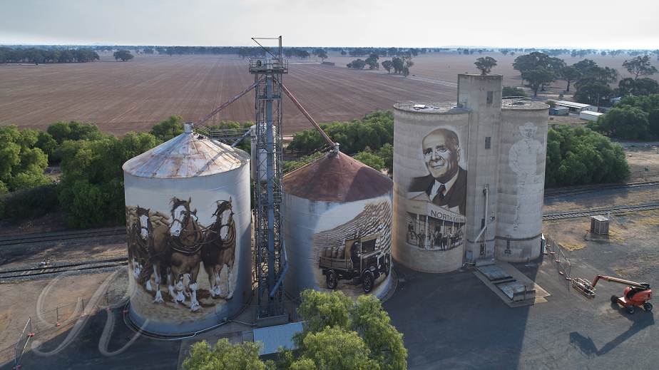
Recent months have seen some activity on the silo art front in the north-east of Victoria. Good things have been happening on the city walls of Benalla as part of the Wall to Wall Arts Festival. Read all about it <HERE>. Benalla is 212 km from Melbourne on the Hume Highway, the main road to Sydney.
Heading north from Benalla there are four painted silos well worth a look in the little towns of Goorambat, Devenish, St James and Tungamah.
I wrote about the Goorambat silo back in October 2018. Since then another painting has been added on the back of the silo. It’s by Dvate and it’s a ripper.
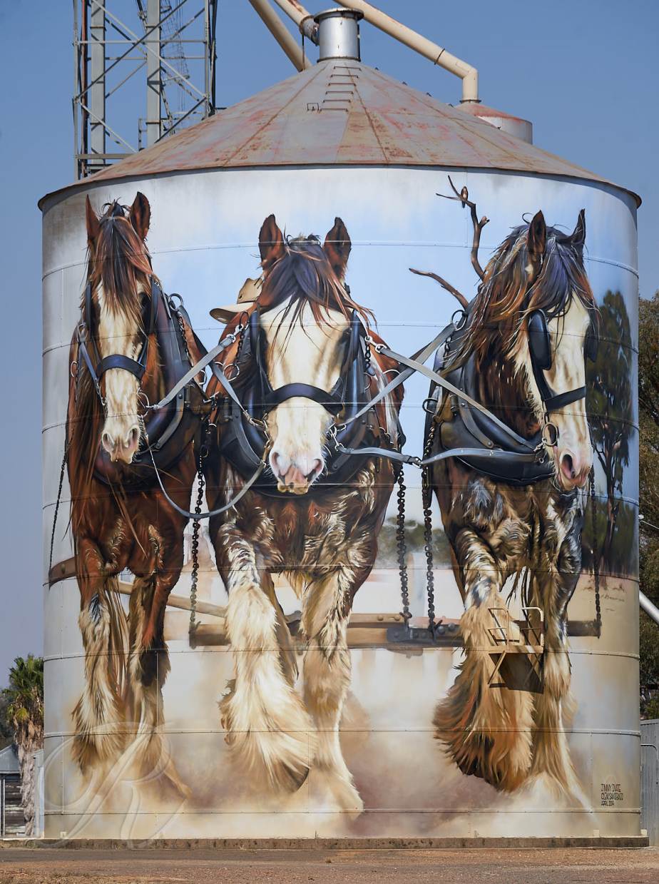
Clydesdale Horses ploughed the fields before the tractor put them out of business. The local farmer Stan Todd may well have been the last to make the switch first using a tractor for the harvest of 1964.
The models for this artwork are from left to right, Lavereen Clement (gelding aged 17 years), Coolibah Ridge Samuel (gelding, 4 years) and Lavereen Banjo (stallion, 19 years) from a photo taken at the 100 year celebration of the Clydesdale in Australia. It’s hard to find a tractor that is anywhere near as attractive.
Next stop on the way north is Devenish. The mural of the WW1 Nurse and modern day medic was unveiled last year to mark the centenary of the end of The Great War. Since then the painting of the Light Horseman has been added and it got its grand unveiling the other day complete with fanfare and dress ups. The Devenish pub was packed. Silo art is very good for beer sales.


St James is next. Like Devenish the pub is right opposite the silos and was doing a roaring trade. It’s for sale so if you want a good pub here it is.
The silos here were built in 1943 and wheat was first delivered in sacks on horse drawn carts. One of the locals was George Coles later Sir George, the founder of the Coles Supermarket chain. The art work by Timothy Bowtell brings that bit of history to life.


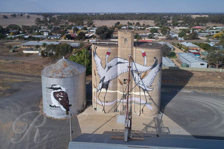
Finally Tungamah for Brolgas and a Kookaburra. The layout here is not at all friendly to the terrestrial photographer.
Here it’s the Police Station not the pub opposite the silos so don’t over-indulge at the previous stops.
Sir Francis Beaufort (1774-1875) a British Naval Commander, later Admiral, devised a scale by which to record wind strength. It was initially for use at sea based on observational characteristic. It ranged from 0 -Calm to 12-Hurricane and, for example at force 3-Gentle Breeze wave crests begin to break. It was adapted for use on land correlated with other observational criteria. I can remember some representative wind strengths from my scouting days :-
In 2001 John E. Bortle came up with an observational scale to record light pollution in the night sky. Bortle 1 is a dark sky with no light pollution, Bortle 9 is an inner city sky where only the moon, planets and a few bright stars are visible. It is based on observations that anyone can make such as whether you can see M15, M4, M5, and M22 with the naked-eye which would be a Bortle 3 – Rural Sky. ( I personally have never seen these but I believe there may be an overpass just north of London where you can see all of them from one vantage point).
Most humans live in cities and unless you live in North Korea the nearest dark sky is quite a drive away. I live in a Bortle 2 area but being in other ways a typical human I hankered for something more. My trip to the desert was made while the moon was but a waning crescent in order to bask in the glow of a Bortle 1. And of course there was only a short break in the clouds on the first night.
The second night found me in the Little Desert contemplating Grass Trees (Xanthorrhoea sp.) and looking for M22 where M stands for Messier
… also known as NGC 6656, is an elliptical globular cluster of stars in the constellation Sagittarius, near the Galactic bulge region. It is one of the brightest globulars that is visible in the night sky. The brightest stars are 11th magnitude, with hundreds of stars bright enough to resolve with an 8″ telescope. M22 is located just south of the Ecliptic, and northwest of Lambda Sagittarii (Kaus Borealis), the northernmost star of the “Teapot” asterism (Wikipedia)
It may be in the photos. If you find it please let me know.


