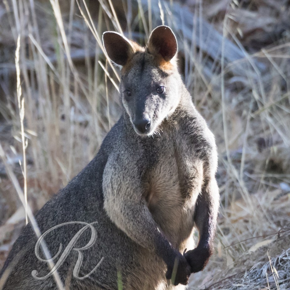
There are two members of the Kangaroo family that are fairly common around the country estate and I encountered both of them on my morning walk. Swamp Wallabies are always around. Eastern Grey Kangaroos come and go. They’re present in fair numbers presently. Brought in, I suspect, by the water that’s available.
Swamp WallabyEastern Grey Kangaroo
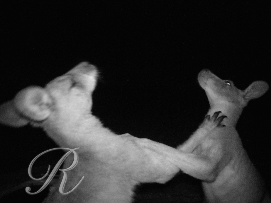
You can see the claws on this big male. One recent night the trail camera caught a couple of roos in a dispute. Thick fur is a useful asset on such occasions …
The Victorian Goldfields are sheep country with some winter cropping. In summer it’s necessary to hand feed. These guys are well off with plenty of shade and a dam close by.
This is the view through the skylight in Melville’s Cave in the Kooyoora State Park in western Victoria.
Captain Melville was a notorious bushranger. He rates his own entry in the Australian Dictionary of Biography. Born Francis McNeiss McNiel McCallum he was well known to police, as they say, back in Scotland where they finally sentenced him to transportation to Van Diemen’s Land for burglary at 15 years of age.
He arrived on 29 September 1838 and in October was placed at Port Arthur in the Point Puer institution for juvenile convicts. In 1839-48 he came before the police magistrate twenty-five times. In 1841 his sentence was extended by two years for felony in February and to life for burglary in July; in September he was sent to Port Arthur for five years. Recommended in 1846 for a year’s probation, he absconded and lived with the Aboriginals for a year. After recapture he was given nine months’ hard labour in chains, an experience repeated in January and August 1850.
Quite how he got to Victoria I don’t know but he arrived in the goldfields in about October 1851 posing as a gentleman and calling himself Captain Melville. Gold was attractive but wielding a pick and shovel wasn’t. He became a bushranger and eventually sufficiently notorious for a reward of £100 to be offered for his capture.
Our Francis boasted of this during a visit to a Geelong brothel and a lady turned him in. Astounding what a woman will do for money. Back to jail.
It was the old Melbourne jail this time where on 12 August 1857 a warder found him strangled by a red-spotted blue scarf. It was never determined if it was murder or suicide.
Plenty of gold came out of the Kooyoora district, Melville’s caves have a commanding view and are surrounded by dense bush, excellent habitat for a bushranger. Whether he spent time here or not though is open to debate. He is known to have made use of a cave on Mt. Arapiles further west.
I spent a little time in the park yesterday evening chasing the landscape. It has been dry and windy and there was a lot of dust in the atmosphere. I found myself on a granite tor up behind the Crystal Mine.
Kooyoora State ParkKooyoora State Park
The dust haze is quite obvious. Late in the afternoon someone off to the east was lucky enough to see a drop of rain.
Kooyoora State Park
Over in the west there was a fair bit of cloud but the horizon was clear. The dust had detracted from the photography during the day but I hoped it would make up for it as the sun went down. Would the sky catch? Oh, yes.
Back in the 1840s John Gould, who was so important in the early cataloguing of Australia’s birds, described the Crested Pigeon as one of the “loveliest in its tribe … not surpassed in beauty by any other form from any part of the world”. This could be overstating it a bit.
But rare birds do tend to be admired more than the common ones and in those days he said that it could only be seen by “enterprising countrymen … prepared to leave the haunts of civilised man and wander in the wilds of the distant interior”. And the best parts of that distant interior were the marshes and ephemeral lakes of the Murray-Darling and Eyre Basins where they followed a nomadic lifestyle to cope with the frequent droughts.
Its range began to increase in the 1920s and since then it has arrived in most of the major cities of Australia and is now a fairly common bird in areas where it was formerly unrecorded. The reasons for this success have been much discussed. Climate change has got a good run and since the temperature has been slowly rising since the Little Ice Age it may have played a part. Other more major changes have occurred however. The reduction of tree cover, creation of permanent watering places and the introduction of exotic weeds all associated with pastoral activity have greatly changed the environment in its favour.
The Crested Pigeon showed great flexibility in its food requirements, consuming seeds and some leaves of many pastoral plants and weeds, notably Paterson’s Curse/Salvation Jane, Echium plantagineum, and with native plants of little importance in its diet. See Andrew Black
I came across a pair the other day that were quite confiding. This is unusual in pigeons because, as a rule, they make good eating. Perhaps they recognised me as a well educated human likely to have read the verdict of Charles Sturt, one of Australia’s great explorers, that their flesh is neither tender nor well flavoured.
It’s about a 20 minute drive from the bats of Bendigo to the Great Stupa of Universal Compassion. When it’s completed it will be the largest stupa outside of Asia and will provide a place of pilgrimage and comfort to Buddhists of all traditions. I’ve been dropping by to watch its development over the last few years.
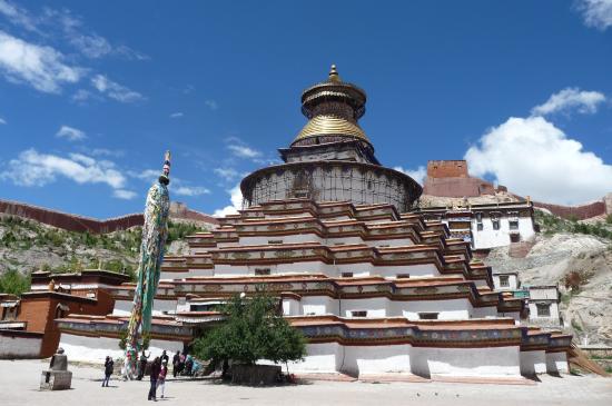
It is the same design and size as the Gyantse Stupa (Kumbum) in Tibet, 50 metres square at its base and nearly 50 metres high.
the original (filched from TripAdvisor)
The Dalai Lama visited and blessed the stupa in 2007.
The stupa is home to many gorgeous objects but perhaps the best of all is a statue of the Buddha carved from a single 18 tonne boulder of jade.
The boulder originated in Canada, the carving was undertaken in Thailand. It was completed in 2008 and then went on a world tour visiting 125 cities across 20 countries where nearly 12 million people have seen it. Many have waited for hours in queues sometimes several kilometres long. It came home last May and now has pride of place inside the stupa.
This is how it is today …
The Great Stupa of Universal Compassion
I was fortunate enough to be given permission to put the drone up.
The assemblies on the ground to the right of the building will be going on top. If you compare it with the Gyantse Stupa you can see that another square story has to be added first.
The plan is for a pair of cranes to lift the top into place sometime in August. I hope to be there.
Bendigo was a boom town in the gold rush days developing rapidly and rather splendidly after 1850. It is the fourth largest town in Victoria with a population of more than 95,000 people. Last time I was there I arrived late in the afternoon with the intention of some night-time photography (see The Bright Lights of Bendigo). As I scouted around I was surprised to find a colony of Grey-headed Flying Foxes in Rosalind Park in the city centre. I made a mental note to return and get some photographs.
Grey-headed Flying Fox
Bats are the only mammals capable of sustained flight. They are a very successful group with more than 12,000 species forming the order Chiroptera (from the Greek χείρ – cheir, hand and πτερόν – pteron, wing). They are the second largest order (behind the Rodentia).
They can be divided into two groups. The microbats are typically insectivorous and use echolocation. They have a near universal distribution being found on all continents except Antarctica. Flying Foxes and their allies are large and restricted to the warm parts of the world. They don’t use echolocation. Their diet consists of succulent fruit, nectar and pollen. The fruit is crushed in the mouth, the juice swallowed and the pulp rejected.
The taxonomy has, of course, been much disputed. That Flying Foxes and microbats have different origins and developed flight independently was once a popular theory. The evidence now seems to support evolution from a single ancestral population that had taken to the air in pursuit of insects.
Flight has the great advantage of mobility at the expense of high energy requirements. Bats solved the problem of flight differently than birds making them even more maneuverable in the air and far less capable on the ground.The wing has a leading edge from the shoulder to the hand and then extends as a membrane that extends to the hind leg and may include the tail. The hind leg has also assumed the duty of hanging the animal from a perch.
Because their hindleg is somewhat tethered bats as a rule cannot take of from the ground (Vampires and the New Zealand Short-tailed Bat may be the exception). However they climb quite nimbly, head first, and once a few feet off the ground can take off losing a little height initially.
Australia has four species of Flying Fox and four more close allies. They are restricted to the northern and eastern forests. The Grey-headed Flying Fox Pteropus poliocephalus is the largest of them (typically 600 – 800 grams but a few as much as a kilogram) and the only one to form permanent colonies in Victoria.
They choose humid shady places for their communal daytime roost and fly out as much as 50km at night to feed. Presumably they have been summer visitors to Victoria for centuries. Europeans have planted ornamental figs and orchards of fruit trees that have induced them to stay. From 1986 there has been a permanent colony in the Botanical Gardens in Melbourne and since then a few colonies have formed at other sites. The Bendigo colony began in 2010 where there are about 2000 bats in summer with about 200 staying over winter.
My sojourn at the seaside basking in the cool weather was over. Back at the farm it had continued hot. The list of visitors to the water point continued to grow in my absence.
We once had a Brushtail Possum come down the chimney. We could hear it stuck in the flue and summoned the chimney sweep to push it down into the wood stove which I hasten to add was not alight. My reward for rescuing it was a bite on the finger.
They’re not all bad news though. At least they save me from eating any of the fruit we grow. And fortunately they don’t eat the grapes. It’s the birds do that.
The strip of coast running from Melbourne west along Victoria’s coast is both splendid and accessible. I am particularly fond of Port Fairy at the western end but lets not get parochial. Anglesea and Aireys Inlet also have their assets a major one being Margaret Lacey. She has recently produced a very beautiful book on the birds her of patch. The photography is superb.
The region has a variety of habitats and Margaret gives the reader very useful information on where to find them all. You should buy the book! It’s well worth the $55. You can get it <HERE>. Mention this page and the postage will be free. Actually the postage is free.
Anyway, while I was there I ran around trying to emulate her …
Singing Honeyeater
Birds with limited distribution are always very special. The Rufous Bristlebird is only found along a coastal strip from Torquay west to the mouth of the River Murray in South Australia (except around Port Fairy!) It is a denizen of coastal heath and dense stands of Coast Wattle. It’s a skulker and can be very elusive. I have seen it in varying places but the success rate at Aireys Inlet is exceptional. Look for it on the footpaths to the west of the lighthouse early or late in the day.
It runs from Torquay to Allansford a distance of 247km. It is splendid from Anglesea to Cape Otway and spectacular from there to Peterborough. Driving it east to west allows it to come to an appropriate crescendo like a well written piece of classical music. You could drive it in a day … but don’t.
The Great Ocean Road
Construction began in September 1919 and was carried out by servicemen returned from the First World War. It was open as far as Lorne by 1922 as a toll road – two shillings and sixpence for a car, 10 shillings for a wagon with more than four horses. Passengers paid one shilling and sixpence, many tried to avoid this by walking along the beach around the toll point.
Presently there is no toll payable but that may not last!
The full length of the road was opened in November 1932.
Great Ocean Road from Teddy’s Lookout, Lorne
A pinnacle still attached to land …
at Aireys Inlet
and a rock that isn’t …
Split Rock, Aireys Inlet
The coast as far as Cape Otway is called the Surf Coast beyond the cape it is called the shipwreck coast. Ship wrecks haven’t been as common since they switched from wind power to more reliable sources of energy.
My advice to the traveler is
remember to drive on the left side of the road
try to avoid the summer school holidays Christmas to early February
don’t rush, spend a few nights on the road
along the surf coast make sure to detour inland to visit the Otways forests and some of the waterfalls
take a detour to the light house at Cape Otway – always worth it but in winter there is the added possibility of a whale passing by
beyond the cape concentrate on the magnificent limestone stacks and cliffs at London Bridge, Loch Ard Gorge, Twelve Apostles, Bay of Martyrs
when it’s done treat yourself to a couple of nights in Port Fairy the nicest town anywhere on Victoria’s coast.