Gayle and I have friends around the globe. The current fires in Australia are making headlines everywhere and friends are emailing almost daily with concerns for our safety. My friends are, of course, more intelligent than the average consumer of the main stream media so I’m writing this to give them some background that the TV news won’t be covering. It is written from a personal perspective. Australian readers can stand down.
If you live in Victoria you live with the threat of bushfire. Every spring the authorities warn us to expect fires and to be ready. Some years the message is that the wet winter has contributed to vegetation growth and the fires will be worse this year. Other years the message is that a dry winter has produced a dry fuel load and the fires will be worse this year. Fires are a fact of life every year but some years are much worse than others.
Living here it is likely that you know someone who has been seriously impacted by fire. In 1969 fire swept across the Geelong to Melbourne Road killing 18 people including a couple of Gayle’s good friends. Gayle’s aunt lost her home in the 2009 fire as did a birdwatching friend of mine. Gayle grew up on Melbourne’s fringe. Her first memory of fire is as a primary school kid standing in the garden directing water from the hose up into the guttering. Mum had blocked the downpipes (traditionally you do that with tennis balls). Dad was at work. Burning embers were raining down on the house which survived undamaged. We have had a couple of adventures ourselves in previous summers when we’ve been camping. These are tales for another time.
Unprecedented seems to be the buzz word this year. There seems to be a flaw in the human mind that quickly diminishes the severity of past events. Perhaps without it we would all be single child families and headed for extinction. The worst in living memory means we haven’t seen anything like it for several weeks. Bushfire and the Australian Landscape have been companions for millennia each shaping the other.
Since European settlement the largest Victorian bushfire in terms of area was in February 1851 which burnt through 5 million hectares (12,355,270 acres). The greatest loss of life occurred in February 2009 – 173 people died. The biggest events earn themselves names …
Black Thursday 1851
Black Monday 1865
Red Tuesday 1898
Black Sunday 1926
Black Friday 1939
Ash Wednesday 1983
Black Saturday 2009
we’re not particularly imaginative with our creek names either Dry Creek, Sandy Creek, One Mile Creek, Two Mile Creek …
So the reality is that wildfire happens often. It is part of the natural cycle of regeneration of eucalypt forests and no matter where you are in Victoria the dominant tree is a species of eucalypt.
Our weather conspires against us. Evaporation greatly exceeds precipitation through our hot dry summers. Add to that the regular cycle as low pressure systems pass by coming from the west. Typically the wind turns northerly, temperatures and wind strength increase over a few days ahead of a westerly change. The days of highest risk are days with temperatures in the 40s (>104°F) and a north wind with speeds above 35kph (20 knots). A fire starting on such a day is likely to head south on a fairly narrow front with windborne embers travelling ahead of it producing spot fires.
When the change in weather comes the temperature drops the wind turns westerly and is usually even stronger for a while. The easterly flank of the fire is now a long fire front. Loss of property is greater after the change.
You are fairly safe in Victoria’s larger towns although I have vivid memories of burning leaves fluttering down on Melbourne suburbs from fires in the surrounding hills. Agricultural areas, once the winter crops have been harvested are reasonably safe. Forested areas are going to burn, if not this time their turn will come. The place you least want to be is on a hilltop in a forested area with a single winding road in and out.
The lesson I took from the last great fire in 2009 is this … When fire breaks out you’re on your own. People died in the chaos. Communications break down. There is no way to know which road offers a safe exit or leads to disaster. On that occasion the chief of emergency services had gone out to dinner and switched off her mobile phone. Leave early.
Since then the authorities have given us an app. It’s quite good especially when you don’t need it. It is pretty slow when you do and it only works if you have internet coverage. More importantly it seems that the community has realised that there is no shame in heading for safety rather than dying with a garden hose in hand. Evacuation has not been mandatory in Victoria until this year.
The Country Fire Authority keeps us informed of the fire risk with categories like Severe, Extreme and Code Red. Houses are not designed to withstand code red fires. When the risk is high a Fire Ban is declared which not only prohibits doing a spit roast outside but also the use of angle grinders, welding, chain saws and any activity of similar risk.
So where are we placed in all of this? We are in an agricultural area of the Goldfields west of centre of the state. The present major fires are in the far east of the state. That doesn’t mean the next fire won’t be here. Earlier this summer a large fire burnt to within 4 km before it was controlled. Even closer, some neighbours 1 km away set their paddock alight driving a car around in long grass. Fortunately the wind was blowing towards their house not ours on the day. The fire was quickly extinguished by our volunteer fire brigade.
Our preparation always starts in spring with cleaning up any fallen branches and mowing the long grass. On 20 acres that’s quite a lot of work but there comes a day when it gets too hot and dry for the grass to grow and we put the mower away until autumn. Council inspections start in November and if you haven’t cut the grass by then you can expect a harsh reminder.
On high risk days we stay close to home and keep an eye on the emergency app and listen to the radio. Ours is a very small community, when fire is getting close the girls get on the phone to share their observations and so we know who is where. You don’t want someone putting themselves at risk trying to rescue you from an empty house while you’re safe and sound 20km away.
Our fire plan is a simple one. Run away. Our greatest risk is a fire starting close and to the north on a code red day. The road we live on runs north-south and is tree-lined, behind us is a creek also tree lined and running north-south. Our electricity supply is strung between poles and comes from the north. Our water supply is rainwater collected off the roof and stored in tanks. Fighting a raging fire with limited water after the electric pumps have quit is an unappealing prospect. The road south is a way better option.
After the change the fire would come from the west. There is little in the way of trees to help it along from that direction. It’s agricultural land, the crops are in and the sheep have reduced the grass to ground level.
A really big fire makes its own wind but the fuel locally isn’t sufficient to do that to us (I hope). Our driveway is 250 metres long and runs between an avenue of Red Ironbarks (Eucalyptus tricarpa). Should they be alight there are two alternative exits, one of which involves cutting two fences. We would go in seperate vehicles one being the mobile home – somewhere to live if the house goes up. The wire cutters are in the mobile home. Wind from the north we head south. Wind from the west we head east.
Our important papers are stored off-site. The house is insured. Life is precious. QED.
For the moment the worst of the effects for us is the smoke. At its worst it will make your eyes water and throat sore. It comes and goes at the whim of the wind.
Just as we’ve forgotten our previous fires we’ve also forgotten our previous droughts. The geologic record shows us that there have been times when Australia has been warmer and wetter than present and also colder and drier. The last decade has been the warmest on record. Of course the record is not all that long. The world has been slowly warming since the Little Ice Age so you’d expect each decade to be a tad warmer than the last.
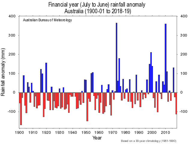
During the last century not only has our temperature increased so too has our rainfall. Drought happens and the last three years have brought us a bad one but not unprecedented and overall Australia is getting wetter. Don’t believe me then take a careful look at this graph from the BoM.
As to climate change and fire the trend should show better in global data than in regional data and it just doesn’t …
many consider wildfire as an accelerating problem, with widely held perceptions both in the media and scientific papers of increasing fire occurrence, severity and resulting losses. However, important exceptions aside, the quantitative evidence available does not support these perceived overall trends. Instead, global area burned appears to have overall declined over past decades, and there is increasing evidence that there is less fire in the global landscape today than centuries ago.
That’s from Doerr & Santin, 2016 the paper is available on line.
The cost of fire depends largely on the density of settlement in fire prone areas. The death toll depends largely on peoples response to fire – currently people are tending to evacuate which will save many lives. The frequency of wildfire is influenced by fuel management. Australia seems to be ambivalent regarding this. When prescribed burns increase summer fires decrease but environmental organisations tend to get excited. Perhaps even more oddly my local reserve may be burnt for the greater good but if I pick up fallen wood from the roadside I may be prosecuted for gathering firewood illegally.
So friends and concerned readers be reassured that we are well but never complacent. On a wider front our hearts go out to those in less fortunate positions and our admiration for our fire fighters knows no bounds. And if you’ve lent us some of yours we thank you sincerely.
If you want to read more about life in a densely settled area on top of a forested hill Google “cockatoo cfa.gov.vic.” Clicking on the top result leads to a comprehensive pdf.


