Goyder was right …

I posted this episode on September 2nd but somehow it disappeared into the void, how embarrassing. Funnily enough it fits between day one, en route at last, and day three, Farina, which you may have read.

***

Day two of the Great Inland Expedition of 2016 would entail driving along the Goyder Highway.

Whilst this might sound like something that could be fixed by putting iodine in the salt, the name commemorates the surveyor George Goyder. The colony of South Australia was founded in 1836 as a free settlement, no convicts transported here! It was to be the very best of British, no unemployment and no crime. The new colony started without police force or jail. Nowadays most South Australians live in Adelaide, are extremely cultured, have double barelled surnames and an intense urge to save the planet with renewable energy. The remaining few are unemployed drug addicts who keep friends and relatives in barrels whilst collecting their unemployment benefits.

The settlers had big ambitions but soon realised that whilst they had a huge area to play with not much of it was fertile.

Explorer Edward Eyre was commissioned to find out what lay to the interior, and ambitious settlers moved out hoping that rain would follow the plough. All too often it didn’t. In 1865 Mr Goyder, the then Surveyor-General of the colony, was asked to map the boundary between those areas that received good rainfall and those that did not. After riding an estimated 3200 km on horseback he submitted his report and map to the state government. The map showed a line of demarcation, the areas north of which being those Goyder judged “liable to drought”, with the areas to the south deemed arable. He discouraged farmers from planting crops north of his line, declaring this land suitable only for light grazing.

The line is essentially the 250mm(10 inches) isohyet. It can be determined on the ground by inspection of the vegetation, north of the line there is mainly salt bush, south of the line is mallee scrub (mallee trees being slender multi-stemmed eucalypts).

Years with good rains led settlers to move north, subsequent droughts broke their hearts and brought them back. The ruins of abandoned farm houses dot the South Australian countryside.

Goyder's Line
Goyder’s Line

We stopped at Burra, a very picturesque town that started out as a single company mining town exploiting a large copper deposit. The mine began operations in 1848 and was largely worked out by 1877 although it operated occasionally until 1981. This was our chance to buy fresh food. Whilst the lovely Gayle shopped I ran around with the camera …

Burra SA

Burra SA

Burra SA

Here we parted from Goyder’s highway which runs northwest from to Crystal Brook. We would head pretty much due north into the arid zone our destination a classic example of drought versus dreams … Farina.

Green Lizard dreaming …

The Birdsville races should have started today but the track is underwater. The ABC reports …

Birdsville Race Club vicepresident Gary Brook said the main Birdsville Cup race would now run on Sunday, a day later than planned.

“With the water that was laying on the track after 50 millimetres of rain overnight, we needed sufficient time to let the track dry, get the mud off, make sure the track was dry and safe and really, to race tomorrow – there just wasn’t sufficient time,” he said.

Roma-based pilot Andrew Luhrs flew nine people out to Birdsville, landing on the town’s main strip.

But he could not park his plane on the gravel cross-strip because of the risk of bogging.

He said he was forced to fly to Boulia, 400 kilometres away, for the weekend.

There is very little accommodation in Birdsville. About 7000 people were expected for the races almost all of those people are camping. Some are in the caravan park in town, the rest are out at the billabong or along the Diamantina River. Either way they are up to their ankles (at least) in mud.

No one will give up and go home … when the heavens open the roads close. How long will they be staying?

In 1986 the roads were closed for so long that the pub ran out of beer. The patrons were reduced to drinking Creme de Menthe and lemonade AKA the Green Lizard. Good luck, guys.

Farina …

After leaving Burra our route took us through Peterborough and Hawker and then north along the corridor between the Flinders Ranges and Lake Torrens.

Edward Eyre came this way on his first South Australian expedition in 1839 and then explored the region more thoroughly in 1840. Lake Torrens is an enormous salt lake stretching 250 km north south with an average width of 30 km. Eyre tried to cross it with horses but found it impossible. From the height of the Flinders Ranges he saw more of the same shiny white mud to the east and indistinctly to the north. Forced to retreat by lack of water he took with him the erroneous belief that Lake Torrens was horse-shoe shaped blocking passage to the north.

John McDouall Stuart from 1858 onward led six expeditions that culminated in the first return crossing of the continent. Stuart’s track runs west of Lake Torrens, we were taking a short cut and would intersect it in due course.

At Lyndhurst we made a brief side trip up the Strzelecki Track to search for the Chestnut-breasted Whiteface. One of our party had not seen this elusive little bird despite several past attempts so we took him to a spot where Gayle and I had had success on previous occasions. We searched on foot until the afternoon wore on. And he didn’t see it once again.

We arrived at Farina as the sun neared the horizon.

A number of things had conspired to draw people north from Adelaide. As dry as it is, cattle and sheep can be grazed in the hinterland, a railway is a good means to transport them to market. The route chosen for the new fangled telegraph that would connect South east Australia to the outside world was Mr Stuart’s route from Adelaide to the north coast. And of course, the science was settled, plough the earth, plant your crops and the rain would come, a theory promoted by scientists of the day such as the noted American climatologist Cyrus Thomas. The settlement here was founded in 1878 as Government Gums. Its name was changed to Farina to reflect the intention to grow wheat. It grew to reach a peak population of approximately 600 in the late 1800s. It was the rail head for a time. In its heyday, the town had two hotels (the Transcontinental and the Exchange) and an underground bakery, a bank, two breweries, a general store, an Anglican church, five blacksmiths, a school and a brothel. No wheat was grown. All that remains today are the ruins and the cemetery.

We pulled into the camp site. The first thing to catch my attention was a magnificent Black-breasted Buzzard. Life can impose some cruel choices upon us. With just minutes of the photographer’s golden hour remaining … the ruins or the bird?

BBBu

As it happened there would be a gibbous moon …

Farina

Farina

and another golden hour in the morning

Farina by day

but I actually prefer the night shots.

I thoroughly recommend the Farina camp ground, showers, clean toilets, scenic and just $5 per person per night.


En route at last …

It has been a very wet winter. We had been watching the weather closely for a month or so. Rain had closed the roads to the Simpson Desert repeatedly. We had gone so far as to make alternate plans – the Nullarbor surely would be dry.

Plan A would take us across the French Line to Poeppel’s Corner and then south via the Warburton Track to the Birdsville Track near Mungerannie. The Warburton River was not in the mood to cooperate. Plan B was to head to Birdsville instead. But before you can cross the desert you have to get there.

The party assembled in the Victorian Goldfields on the 12th of August. The quartet was Mark and Will, both professional biologists thrilled to get into the field without the burden of their jobs to consider, the lovely Gayle and myself. After last minute packing we set off the next morning.

During the day we crossed the South Australian border into the Riverland. Quarantine restrictions are in force to protect the region’s agriculture. Honey, fresh fruit and vegetables are forbidden. Canned, processed and freeze-dried foods are OK as are meat, eggs, dairy products, nuts, mushrooms and seeds. Potatoes are forbidden, sweet potatoes are permitted, the rules are somewhat convoluted. If arriving from Tasmania (presumably by plane) you may take date palms but coming from Victoria we must leave our date palms behind. Soil is forbidden no matter what … how do Tasmanian date palms get on in hydroponics?

A little over 600 km later we camped for the night in the South Australian Mallee.


SAMallee

Not far from our camp we found the excavations of the Southern Hairy-nosed Wombat. This is a creature that mines on a grand scale. Their burrows are interconnected into warrens that are shared by as many as ten wombats. We staked out a burrow and hoped that as night fell one would choose this particular exit. Despite considerable patience (two beers at least) we were not rewarded. However, a return visit later in the night surprised one above ground. It didn’t stay long.

It was one very cold night.

The Great Inland Expedition 2016 …

It started as a thought bubble, why don’t we drive across the Simpson Desert?

According to the frequently erroneous Wikipedia, the Simpson is the world’s largest sand dune desert, with the world’s longest dunes. It covers 176,500 km2 (68,100 sq mi) and the dunes range in height from 3 metres in the west to around 30 metres on the eastern side.

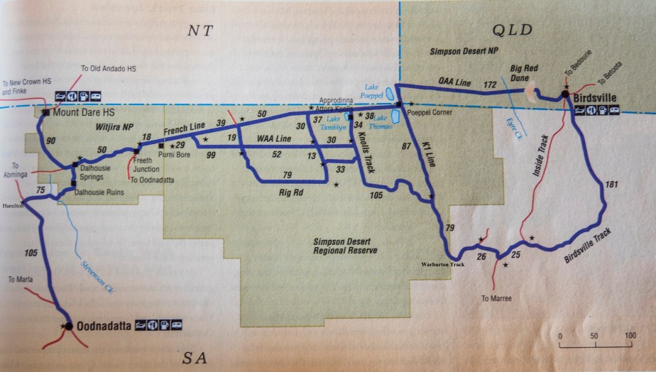
There are no made roads and no fuel stations. The tracks are well-defined, even sign-posted in places, but you must take them just as you find them. The prevailing wind is from the west. This has a profound effect on dune morphology, the west face of the dunes has a slope of 10-20° whilst the eastern face has a slope of 34-38°. West to east seems a good idea for a beginner.

There are a number of routes to choose from. Of the two most popular, the French Line is reputed to be harder than the Rig Road. So the Rig Road seems another good idea for a beginner. We chose the French Line.

Last fuel on the west can be either Oodnadatta or Mount Dare Station the next, on the east, is at Birdsville (taking the QAA Line from the end of the French Line) or Mungerannie (taking the Warburton Track). Mount Dare would have been a little out of our path but shortens the distance a little. The longest of the possibilities is Oodnadatta to Mungerannie at about 750 km.

A solo trip seems foolhardy for a beginner so I invited some friends along. Two high clearance 4WD vehicles were set up for the gig, an FJ Cruiser (petrol) and a Landcruiser series 70 ute (diesel). Both have electric winches, radio and a shovel – the first self rescue item to turn to in sand. There was one satellite phone. And of course, the sand flags. We would carry some extra fuel.

We would be travelling in the tracks of countless aborigines and many other Europeans including Mrs Middleton’s little boy, Johnny; and Bill from Cunnamulla who did it twice on his bike. The first white explorer to see the Simpson was Charles Sturt back in the 1840’s. It was in the way of his attempt to travel north to the geographic centre of Australia. He was unimpressed …

We had penetrated to a point at which water and feed had both failed … The spinifex was close and matted, and the horses were obliged to lift their feet straight up to avoid its sharp points. From the summit of a sandy undulation close upon our right, we saw that the ridges extended northwards in parallel lines beyond the range of vision, and appeared as if interminable. To the eastward and the westward they succeeded each other like the waves of the sea. The sand was of a deep red colour …

In 1880, Augustus Poeppel, a surveyor with the South Australian Survey Department made an incursion from the east along the 26th parallel, the Queensland/South Australia border, and marked the point where they meet the Northern Territory. He placed the tristate junction a little too far west, in the middle of what is now Lake Poeppel. It has since been moved to its correct position and is called Poeppel’s Corner.

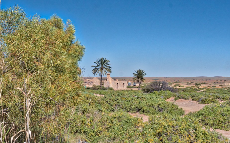
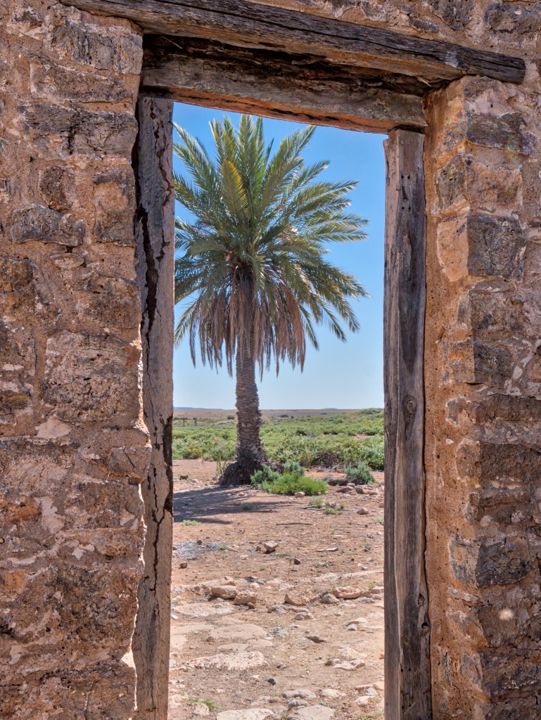
Development on each side of the desert occurred quite early. Edward Meade Bagot took up the lease on Dalhousie Station on the western fringe in 1873. Birdsville, on the eatern fringe,  dates from about 1881 initially as Diamantina Crossing but quickly renamed. The Birdsville Post Office opened in January 1883.

David Lindsay, a formidable explorer, joined the dots. In January 1886, the height of summer, he set out from Dalhousie on the west side of the desert with Paddy – a Wangkangurru Aboriginal man and Charles Bagot, the pastoral lessee of Dalhousie Station and headed east into the Simpson Desert. He visited and documented a series of nine Aboriginal wells and travelled to the Queensland/Northern Territory border. Considering the country further eastwards to be “discovered” and also considering Mr. Bagot’s health, he backtracked to Dalhousie.

In 1886 Warburton, properly Peter Egerton-Warburton (1813-1889) penetrated from the south. He explored the area around the north shore of Lake Eyre searching unsuccessfully for Cooper Creek but found a large river which was subsequently named the Warburton River. He traced this north to the Queensland border. We hoped to follow his track south from Poeppel’s Corner but his river just happened to be in flood.

The name Simpson Desert was coined by Cecil Madigan, in honour of Alfred Allen Simpson, an Australian industrialist, philanthropist, geographer, and president of the South Australian branch of the Royal Geographical Society of Australasia. Mr Simpson was the owner of the Simpson washing machine company. Madigan made an aerial reconnaissance flight over the desert in 1929, which proved that the desert was composed of numerous parallel sand dunes, with no evidence of permanent water.

Ten years later Madigan crossed the desert by camel and celebrated being the first across the entire desert in the very readable Crossing the Dead Heart.

He was not, of course, the first, in fact not even the first European. That honour goes to Ted Colson who had traversed the full width of the desert in both directions three years earlier.

On 27 May 1936 after a season of good rains, Colson set off from Mount Etingamba 53 miles north of Bloods Creek with a lone aboriginal companion Eringa Peter. He carried provisions for two months, a compass and maps and travelled due east following the 26th parallel. Facing approximately 140 miles of unknown country, they subsequently traversed over a thousand sand ridges. He named some hills near the western side after his wife Alice, and a dry salt feature Lake Tamblyn after John Tamblyn his school master. His course took him to Poeppel’s Corner then on to Birdsville which they reached on 11 June, and set out for the return journey three days later. He had missed the corner post on the outward trip (by only 300 yards), but found it on the return journey and took photographs as it was still in good condition a little over 50 years after its placement. They arrived back at Bloods Creek on 29 June 1936, after 36 days and almost 600 miles of travel.

The first crossing by car was by Reg Spriggs with the wife and kids in September 1962. They took 12 days to travel from Andado Station to Birdsville in a short wheelbase Nissan Patrol. The following year French Petroleum commissioned a seismic survey which involved bulldozing a route a little to the south of the Spriggs’ – the French Line.

So, the plan …

 Inland 2016


You can click  on the map to enlarge it.


The Races …

Birdsville, Queensland, has a population of about 100. The annual races are run in the first week of September. T’other day all roads were closed and the track was underwater. The camp grounds were a sea of mud, you grew taller as you walked about.

The weather forecast for …

Thursday 1 September

Summary
Min 14
Max 22
Rain.
Possible rainfall: 25 to 40 mm
Chance of any rain: 100%

Cloudy. Very high (near 100%) chance of rain. The chance of a thunderstorm. Heavy falls possible. Winds east to southeasterly 15 to 20 km/h turning southerly during the morning then tending northwest to northeasterly 25 to 40 km/h during the afternoon.

courtesy of the BoM on August 30th.

Tipped to win …

2a237cdfc47f71d73b58dc071a0acf7d


The Great White Ant …

Well, finally, Australia has a government.

Colourful Christopher got in early with his claims, Bill Shorten was still swanning around in self congratulation, but it has come to pass. The coalition has the numbers, perhaps number, a plural seems a slight exaggeration.

The waffling banker  will be the Prime Minister. You could switch the initial letters around without getting further from the truth … the baffling wanker. The small L Liberals (where L is short for loyalty) can rejoice that not all of them lost their seats. Pity really. Given that both sides of politics promised to totally disregard economic reality and race us to bankruptcy, it’s a task that could have been safely left to Labor. Their track record being impeccable in that regard.

Abbott would have made mincemeat of Shorten. He could have mentioned the boats, countered the suggestion that Liberal contenders are prone to tell lies with a very brief replay of Julia promising no carbon tax and, of course, he could have promised no carbon tax. Turnbull can’t do that having promised us a carbon tax. Nor could he run on his record, waffling on like a scratched record is no substitute for achievement. Turnbull put considerably more effort into overthrowing Abbott than in winning an election. But then winning an election is a little like face to face combat, unlike shuffling around dispensing innuendo and looking for an opportunity to slip a knife in someone’s back.

The only reason for his rise to power was the fact that he looked better in the polls than Abbott. He now looks like the self made millionaire … that inherited billions. Much was made of his appeal to progressive types. It didn’t dawn on the small L Liberals that progressives would like him but not vote for him in a fit. In another era I’m sure Jeff Kennett liked John Brumby a great deal (and Abbott would positively love Bill Shorten). We all approve of weak enemies.

Turnbull has a vision, we know, it’s Turnbull, Prime Minister. Does he have a vision for Australia, I think not.

Mr Shorten is very happy with his achievement, Mr Turnbull is entirely happy with his. It’s the people of Australia that lost the election.

Good Morning Melbourne …

The Photographer’s Ephemeris revealed that a spot on the Yarra River near the Westgate Bridge would give me a great view of the sun coming up over good old Melbourne Town and this time, the ephemeris had much better control over the weather. Just before sunrise …

bobmcgee.live

The glow intensified and I was rewarded for my efforts by this …

bobmcgee.live

A short walk gives a better view of the docks …

bobmcgee.live

and if you look very carefully you can see a number of hot air balloons (and you can always get a better view by clicking on the photos, the back arrow on your browser returns you to this page), I wasn’t the only one saying good morning Melbourne. I retraced my steps and caught them as they crossed the city skyline …

bobmcgee.live

What an adventure they were embarked on …

Nine passengers have jumped from a hot air balloon hovering over Melbourne’s Port Phillip Bay onto a police boat below following fears the balloon, which was low on fuel, would ditch into the water.

While the drama unfolded over the bay, a second hot air balloon crashed into a suburban street in nearby Aspendale Gardens.

No one was hurt from either balloon. The one over the bay was sufficiently buoyant, once the passengers had jumped off, to fly on and land ashore.