The strip of coast running from Melbourne west along Victoria’s coast is both splendid and accessible. I am particularly fond of Port Fairy at the western end but lets not get parochial. Anglesea and Aireys Inlet also have their assets a major one being Margaret Lacey. She has recently produced a very beautiful book on the birds her of patch. The photography is superb.
The region has a variety of habitats and Margaret gives the reader very useful information on where to find them all. You should buy the book! It’s well worth the $55. You can get it <HERE>. Mention this page and the postage will be free. Actually the postage is free.
Anyway, while I was there I ran around trying to emulate her …
Singing Honeyeater
Birds with limited distribution are always very special. The Rufous Bristlebird is only found along a coastal strip from Torquay west to the mouth of the River Murray in South Australia (except around Port Fairy!) It is a denizen of coastal heath and dense stands of Coast Wattle. It’s a skulker and can be very elusive. I have seen it in varying places but the success rate at Aireys Inlet is exceptional. Look for it on the footpaths to the west of the lighthouse early or late in the day.
It runs from Torquay to Allansford a distance of 247km. It is splendid from Anglesea to Cape Otway and spectacular from there to Peterborough. Driving it east to west allows it to come to an appropriate crescendo like a well written piece of classical music. You could drive it in a day … but don’t.
The Great Ocean Road
Construction began in September 1919 and was carried out by servicemen returned from the First World War. It was open as far as Lorne by 1922 as a toll road – two shillings and sixpence for a car, 10 shillings for a wagon with more than four horses. Passengers paid one shilling and sixpence, many tried to avoid this by walking along the beach around the toll point.
Presently there is no toll payable but that may not last!
The full length of the road was opened in November 1932.
Great Ocean Road from Teddy’s Lookout, Lorne
A pinnacle still attached to land …
at Aireys Inlet
and a rock that isn’t …
Split Rock, Aireys Inlet
The coast as far as Cape Otway is called the Surf Coast beyond the cape it is called the shipwreck coast. Ship wrecks haven’t been as common since they switched from wind power to more reliable sources of energy.
My advice to the traveler is
remember to drive on the left side of the road
try to avoid the summer school holidays Christmas to early February
don’t rush, spend a few nights on the road
along the surf coast make sure to detour inland to visit the Otways forests and some of the waterfalls
take a detour to the light house at Cape Otway – always worth it but in winter there is the added possibility of a whale passing by
beyond the cape concentrate on the magnificent limestone stacks and cliffs at London Bridge, Loch Ard Gorge, Twelve Apostles, Bay of Martyrs
when it’s done treat yourself to a couple of nights in Port Fairy the nicest town anywhere on Victoria’s coast.
The hinterland of the Great Ocean Road is the Otway ranges. These are low mountains that formed in the rifting process that broke up Gondwana. The ranges were once clothed in forest and quite extensive remnants still exist in the Great Otway National Park.
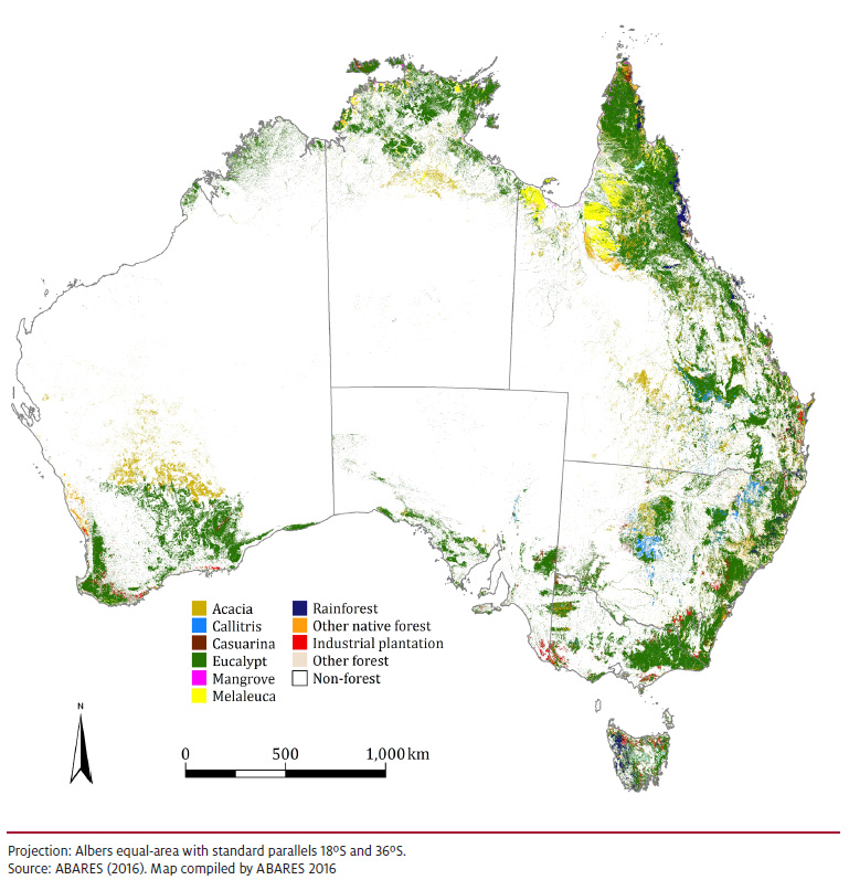
Forests have everything to do with rainfall. If we look at a map of Australian Forests we find them concentrated down the east coast, across the wetter tropics and in the south-west. A rainfall map or a population density map look broadly similar. The white patch ranges from semi-arid to desert and shows how dry a continent Australia is.
I borrowed the map from the Department of Agriculture and Water Resources. You should have a look <HERE> if you need further information. Perhaps because Australia has relatively little forest the definition used is particularly generous. If there are trees that shade a fifth of the ground it’s a forest. Real forest, tall trees with extensive canopies such as we find in the Otways constitutes only a fraction of what’s shown on the map.
Rainfall in the Otway Ranges from 700 to 1400mm (27 – 55ins). If you lived there you’d have to mow your lawn every week not just a few times in the spring like I do.
The forest types include wet sclerophyl characterised by the magnificent Mountain Ash Eucalyptus regnans and temperate rainforest characterised by Myrtle Beech Nothofagus cunninghamii. This is the furthest west that you will find rainforest in Australia. Throw in some ferns and the odd waterfall and you have a very pretty spot for a picnic … watch out for the leeches.
Eucalyptus regnans Mountain AshKangaroo Fern
Australian King Parrots and Crimson Rosellas may well join you at the picnic table while Gang Gang Cockatoos stay a little further back. The habitat is perfect for Lyrebirds and Pilotbirds but they won’t be joining you. They haven’t made it across the gap from the forests west of Melbourne. Nor has the Sooty Owl but this is the place to look for the elusive Grey Goshawk.
I have enjoyed a few days in Anglesea on Victoria’s coast. The sea imposes a moderating influence on the weather. It was a cool and pleasant interlude while at home it was hot. Adding to my personal sense of moderation was the pleasant company and generous hospitality of the very good friends I was staying with.
Anglesea is towards the eastern end of the Great Ocean Road. If you’re traveling east to west it’s where the journey starts to be interesting. The road is Victoria’s premier tourist attraction and although I have mixed feelings about it there is no doubt that it is both visually splendid and worth a fortune to the state’s economy.
It’s been in the news a bit lately because, woe be upon us, erosion. The media have been discussing the impending crisis in terms of climate change and sea level rise. Thousands of tourists travel thousands of miles to see the effects of thousands of years of erosion. Sea stacks, arches, steep cliffs are all the result of erosion. And we’ve just started making a fuss about … erosion.
The Great Ocean Road
Coasts can be classified in several ways one way is to divide them into coasts of submergence and coasts of emergence. There are nice examples of both in the map above. To the right is Port Phillip Bay. At the height of the last glaciation the Yarra River ran across a plain and discharged into the ocean at the heads. As the sea rose the plain was inundated providing Melbourne with a large bay to sail around looking at a coast of submergence. For most of its length the Great Ocean Road skirts a coast of emergence.
Emergent coasts are a result of local tectonic uplift of the land surface or a fall in the elevation of sea level because of a reduction in the water volume of ocean basins. Quite often, emergent coasts have rocky coastlines with cliffs and nearly flat platforms that extend inland where older coastal plains have been tectonically raised and are now elevated above the modern land and water interface.
Another way of classifying coasts is as erosional or depositional.
In places where there is an abundance of wave energy or ocean currents and/or a lack of sediment available for deposition, erosion of the coast will be the dominant mechanism of change. Quite often, erosional coasts are narrow and characterized by resilient rocky shorelines that are exposed to high energy waves and supply relatively little sediment to the adjacent shore.
Where deposition dominates the land is advancing, where erosion dominates the land is in retreat.
One of the features people go to see is the Twelve Apostles.
Twelve Apostles in 2003 – Wikipedia
There were never twelve but there’s one fewer today.
These stacks are formed of limestone that was laid down under the sea about 23 million years ago. The region was subsequently uplifted. The seaward edge of the uplifted land has been undergoing erosion ever since. At the height of the last glaciation, 21,000 years ago, sea level was about 125m lower than at present. (And has been as much as 2m higher in the intervening period.) The cliffs and stacks we see today have been carved out by the Southern Ocean since then.
The sea may have a moderating influence on the temperature but it can have a savage impact on the land. That bulge in Victoria’s coast and the Southern Ocean are not in equilibrium. The sea will continue to eat that coast regardless of further sea level rise.
So this African sojourn comes to an end. As always when I’m writing about travel I have picked up new subscribers. Welcome to you, it’s nice to know that there are people out there, but what have you got in store now?
My neck of the woods is the Goldfields region of Victoria, Australia. It has a rich history and is rich in wildlife. People travel long distances to see Australia so stick around and I’ll show you what I can of it.
This may not be as exciting as an elephant about to charge the side of the vehicle but I took it this morning about 200 metres from my house.
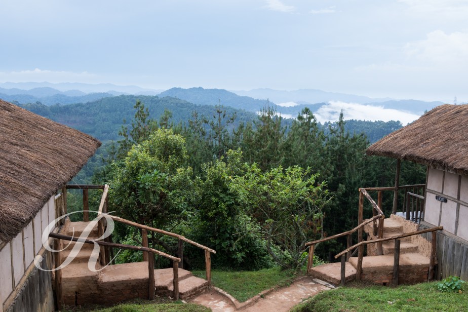
Mountains are often shrouded in cloud, rainforests wouldn’t be rainforests without the rain. Our stay in Bwindi was probably quite typically cloudy and rainy but the day we left was a gem. If you came here every day you could probably expect an experience like this about once every four hundred years.
The mountains in the background are the Virungas which mark the borders of Uganda, Rwanda and the Democratic Republic of the Congo. There are eight major volcanoes in the chain including Mount Nyiragongo, an active volcano that I climbed last year. See that account <HERE>. The night-time time-lapse is well worth a look.
From here it was a drive to Entebbe and a flight home.
Part of Bwindi Impenetrable forest is at high altitude (up to 2,607 metres or 8,550 feet). So despite the proximity to the equator temperatures are relatively pleasant. There are plenty of birds to be found but because of the dense forest finding them is sometimes challenging.
The boys had seen both Mountain and Lowland Gorillas in the past so they went bird watching.
The Gorilla trackers met at the visitor centre where we were entertained by some enthusiastic dancing from some of the local ladies.
Scouts are sent out early to locate the gorillas. We were briefed and assigned to teams. We would be walking from one to eight hours.
I was in a party of eight. We were driven to our start point which was on the top of a ridge. And over the edge we went. It was steep and because of very recent rain it was slippery. There was no formed track, the guides were cutting a way for us.
Fortunately for me we found our gorillas after two hours. We were instructed to leave our back packs and food with the porters and make our way towards the gorillas. We would be with them for an hour but we were not to touch or disturb them.
The party of Mountain Gorillas consisted of two males, two females and two babies. The males slept or pretended to as we watched, while the females and young played in the trees until they were ready to join the others on the ground. It was an amazing experience being so close up with nothing between us. They did not seem to mind that we were there and moved among us without fear.
photo – GHDphoto – GHDphoto – GHD
Our guide made sure everyone got good photo opportunities and didn’t short change us on the time but it was soon time to head up hill. Now the hard work would start.
I was very glad that I had hired a porter. She was a lovely young lady in her mid twenties named Gertruda. She was very fit and enjoyed her work helping others to see gorillas in the forest. Gertruda carried my backpack and watched my every step down and up the steep and slippery mountain. We were very friendly by the end of the trek and both enjoyed the experience we shared together.
Gertruda and an exhausted but elated client
Seeing the gorillas is something you really must do when visiting Uganda. A booking is essential and hiring a porter makes the trekking less strenuous.
Back at the visitors centre you enjoy a celebration with your group of your achievement and a certificate is presented to each individual.
An amazing life-time experience in Bwindi National Park.
Time to say farewell to Kidepo National Park in the far north-east of Uganda and head for Bwindi in the far south-west. It was a two day drive spending another night in the Kampala Metropole.
Highlights en route included …
Shoebill
and standing with one foot in the northern hemisphere and the other in the southern. Oddly enough this was in a little town called Equator.
Bwindi National Park protects 331 square kilometres of the Bwindi Impenetrable Forest. For species diversity there is nowhere better in East Africa. The forest is home to more than 1,000 species of flowering plant, Mountain Gorillas, Chimpanzees, 118 other species of mammals and approximately 350 species of birds including a good proportion of the Albertine Rift Endemics.
We were staying on top of the mountain at Gorilla Mist Lodge.