Sadly is not abolished from the world but rarely have I seen it so blatantly advertised …

and pray that there's intelligent life somewhere out in space
Sadly is not abolished from the world but rarely have I seen it so blatantly advertised …
In Stuart Mill there is, to be sure
a flourishing entrepreneur
the product of sheep
reasonably cheap
at three dollars a bag of manure.

I was impressed by the trouble this guy has gone to with his sign. It’s usually just a roughly scrawled “Sheep poo $3”.
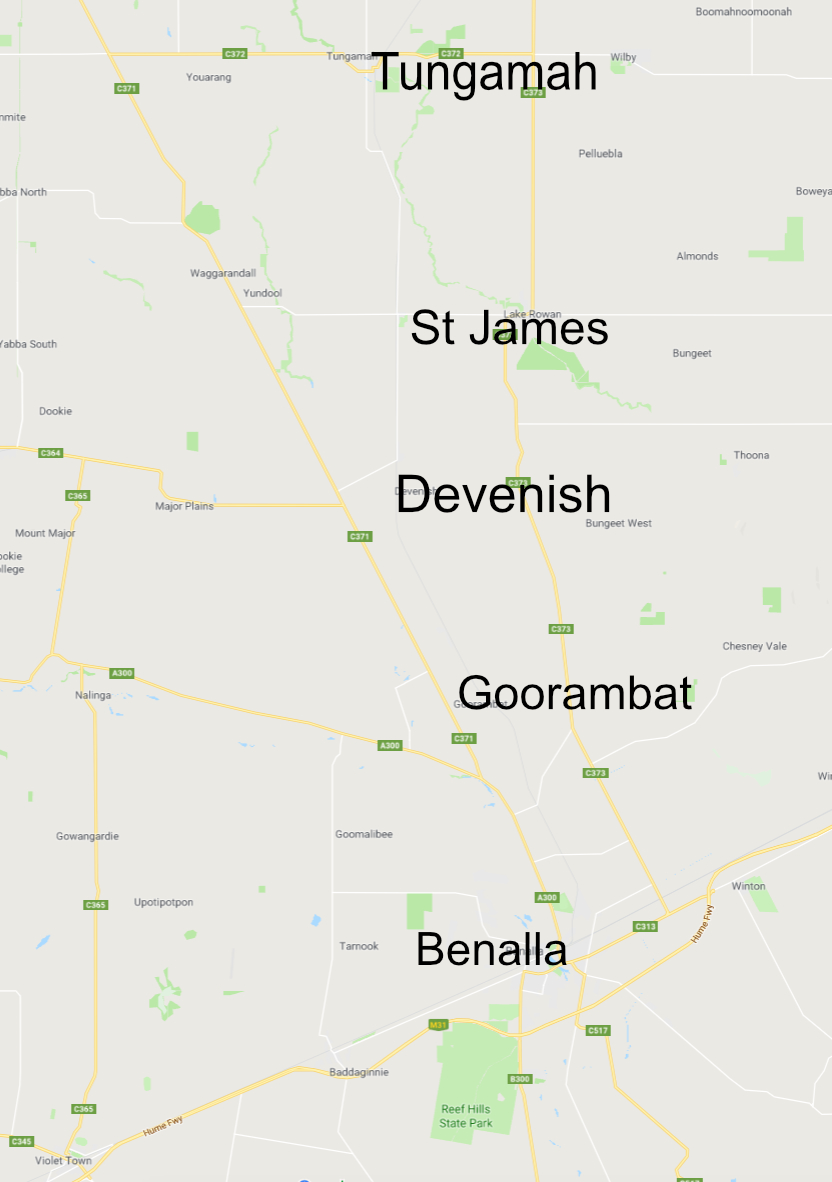
Recent months have seen some activity on the silo art front in the north-east of Victoria. Good things have been happening on the city walls of Benalla as part of the Wall to Wall Arts Festival. Read all about it <HERE>. Benalla is 212 km from Melbourne on the Hume Highway, the main road to Sydney.
Heading north from Benalla there are four painted silos well worth a look in the little towns of Goorambat, Devenish, St James and Tungamah.
I wrote about the Goorambat silo back in October 2018. Since then another painting has been added on the back of the silo. It’s by Dvate and it’s a ripper.
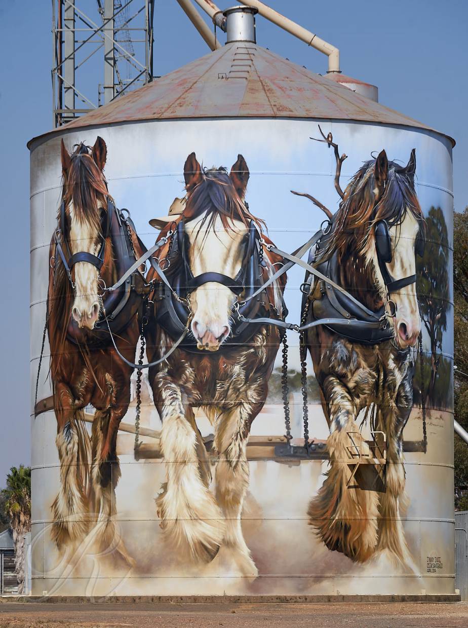
Clydesdale Horses ploughed the fields before the tractor put them out of business. The local farmer Stan Todd may well have been the last to make the switch first using a tractor for the harvest of 1964.
The models for this artwork are from left to right, Lavereen Clement (gelding aged 17 years), Coolibah Ridge Samuel (gelding, 4 years) and Lavereen Banjo (stallion, 19 years) from a photo taken at the 100 year celebration of the Clydesdale in Australia. It’s hard to find a tractor that is anywhere near as attractive.
Next stop on the way north is Devenish. The mural of the WW1 Nurse and modern day medic was unveiled last year to mark the centenary of the end of The Great War. Since then the painting of the Light Horseman has been added and it got its grand unveiling the other day complete with fanfare and dress ups. The Devenish pub was packed. Silo art is very good for beer sales.


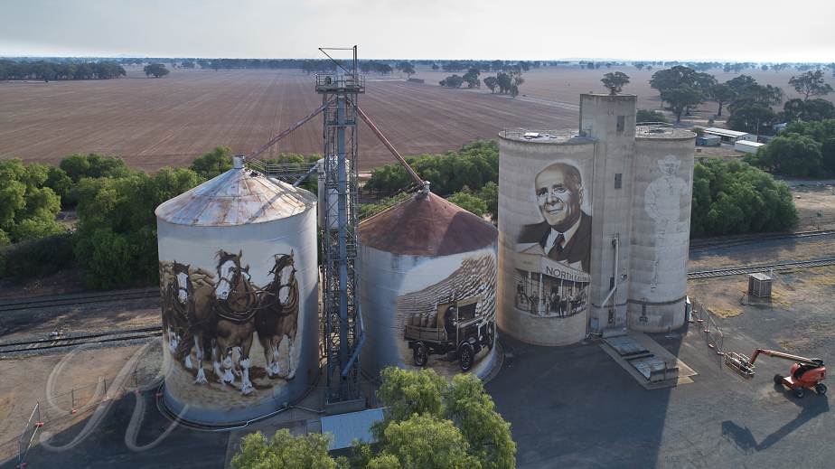
St James is next. Like Devenish the pub is right opposite the silos and was doing a roaring trade. It’s for sale so if you want a good pub here it is.
The silos here were built in 1943 and wheat was first delivered in sacks on horse drawn carts. One of the locals was George Coles later Sir George, the founder of the Coles Supermarket chain. The art work by Timothy Bowtell brings that bit of history to life.


Finally Tungamah for Brolgas and a Kookaburra. The layout here is not at all friendly to the terrestrial photographer.
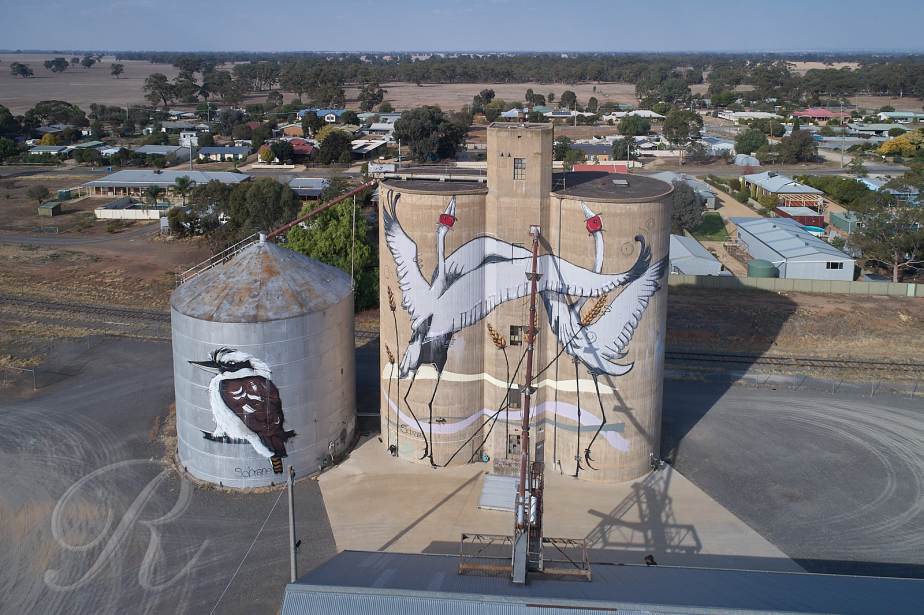
Here it’s the Police Station not the pub opposite the silos so don’t over-indulge at the previous stops.
The visitor to Victoria’s goldfields has a number of opportunities to get underground. The most authentic has to be Carman’s Tunnel. There is no tourist hype, there’s not even any electricity which could be why there is no EFTPOS. The $7.50 for adults and $2.50 for children will need to handed over as real money. Excellent value.
The mine is located at the end of Perkins Reef Road in Maldon. It’s just opposite the North British Mine site, the famous quartz kilns and the ruins of Oswald’s Workshops.
Currently tours run on Saturdays, Sundays, Public Holidays and School Holidays (closed Christmas Day, Boxing Day, and Good Friday) at 1:30pm, 2:30pm, and 3:30pm. Each tour takes 30 – 40 minutes. You can check for changes <HERE>.
Maldon was a very gold rich area and the concept of tunneling through extremely hard rock until you hit a reef was sufficiently attractive to induce investors to part with their money. The Great International Quartz Mining Company was formed in 1882 and drilled 600 metres of tunnel over a period of two years and two months. Reports of the yield vary from nothing to next to nothing and the project was abandoned.

Initially the mining proceeded by one man swinging a sledge hammer at a drill held by a second man. They changed places from time to time. Each was given two candles per day to last their 10 hour shift. If they broke a candle they could get a replacement with the cost deducted from their wages. Be careful with the candle.
At the end of the week the holes would be filled with powder and the rock would be blasted. Be very careful with the candle.
Progress was about a metre a week. Across the road at the North British Mine Robert Dent Oswald was pioneering and manufacturing compressed air drills. Progress picked up considerably once these were adopted. If the miners welcomed the new regime their enthusiasm would soon be extinguished by the silicosis that cut short their lives.
A couple of Oswald’s Compressed Air Drills remain in the mine …


While the Great International Quartz Mining Company was throwing money into a hole in the ground The North British, just a stone’s throw away, was hauling money out. It was one of the last of Maldon’s mines to close, by 1926 it had yielded more than 242,000 ounces of gold.
Carman’s Tunnel is well worth a visit. The temperature inside is very mild no matter what the day is doing outside. The floor is pretty level. Where else can you get a tour by candlelight?
The North British Mine site is also fascinating. Kilns were used to roast the quartz making it easier to crush before it went into the cyanide pits for gold extraction. The kilns and pits are well preserved and there is sufficient interpretive signage to make sense of the rest of the ruins. Entry is free. Learn more <HERE>.


Sir Francis Beaufort (1774-1875) a British Naval Commander, later Admiral, devised a scale by which to record wind strength. It was initially for use at sea based on observational characteristic. It ranged from 0 -Calm to 12-Hurricane and, for example at force 3-Gentle Breeze wave crests begin to break. It was adapted for use on land correlated with other observational criteria. I can remember some representative wind strengths from my scouting days :-
In 2001 John E. Bortle came up with an observational scale to record light pollution in the night sky. Bortle 1 is a dark sky with no light pollution, Bortle 9 is an inner city sky where only the moon, planets and a few bright stars are visible. It is based on observations that anyone can make such as whether you can see M15, M4, M5, and M22 with the naked-eye which would be a Bortle 3 – Rural Sky. ( I personally have never seen these but I believe there may be an overpass just north of London where you can see all of them from one vantage point).
Most humans live in cities and unless you live in North Korea the nearest dark sky is quite a drive away. I live in a Bortle 2 area but being in other ways a typical human I hankered for something more. My trip to the desert was made while the moon was but a waning crescent in order to bask in the glow of a Bortle 1. And of course there was only a short break in the clouds on the first night.
The second night found me in the Little Desert contemplating Grass Trees (Xanthorrhoea sp.) and looking for M22 where M stands for Messier
… also known as NGC 6656, is an elliptical globular cluster of stars in the constellation Sagittarius, near the Galactic bulge region. It is one of the brightest globulars that is visible in the night sky. The brightest stars are 11th magnitude, with hundreds of stars bright enough to resolve with an 8″ telescope. M22 is located just south of the Ecliptic, and northwest of Lambda Sagittarii (Kaus Borealis), the northernmost star of the “Teapot” asterism (Wikipedia)
It may be in the photos. If you find it please let me know.


I’ve just spent a couple of days in Victoria’s deserts. The Big Desert covers about 1500 square km so compared to the Sahara (9.2 million square km) it’s not all that big at all. But it is bigger than the Little Desert. Neither of our deserts are devoid of vegetation but they are sandy and rainfall is not overly generous. To their north is another similar area – the Sunset Country.
The dunefield that covers most of these three areas came from South Australia courtesy of the prevailing westerly wind during the ice ages. Conditions were much drier back then. Collectively the dunefield is known as the Lowan Sands. And even the Sahara can only boast about 138,00 square km of actual dunefield.

First stop was the south-east corner of the Big Desert along the Netting Fence and Chinaman Well tracks.
The area is rich in pioneer archeology. In 1885 the Netting Fence was constructed to keep the Dingo out of the sheep and wheat growing areas to the south and to keep the rabbits from spreading further north. The grandfather of one of my favorite co-workers was a dogger back in the day. The fence helped to keep down recruitment of dogs from the desert replacing those shot on the agricultural land. It did little to slow the spread of the rabbit.
Bores and windmills provided water for the sheep and cattle that were herded through the desert. The remains can be found, mostly scattered across the ground but there is one in quite good condition along the Chinaman Well Track.

I also found three old ploughs, lying around like skeletons, with the vegetation growing up between their ribs.


Whether they represent failed attempts to cultivate the area or whether it was a handy spot for the locals to dump old ploughs I don’t know.
In any case the pioneers did it pretty tough out here, it’s a long walk to anywhere especially over soft sand.
I revisited the windmill at 2 am and was lucky enough to get a short break in the clouds.

Back in the US students and their parents are contemplating the Spring Break and whatever shenanigans go with it. Around where I live the farmers are hoping for a decent autumn break, a far more prosaic event when precipitation catches up with evaporation and a winter crop can go in.
The last significant rain was in January. The other mainstay around here is sheep. The paddocks are fairly bare. Feed is being delivered by truck or tractor.
We may get a little rain tonight. Beyond that the outlook is dry for a while. Nonetheless preparations are under way. Fertiliser piles that appeared in the last few weeks are now slowly disappearing. Not everyone calls in the airforce – some spread it the old-fashioned way …


Writer and artist … Pascal Jousselin.
Easy question. Just as I thought I was smarter than a chimpanzee I thought I knew which planet is nearest to Earth. If you’re bold enough, write your answer in the comments before watching the video …
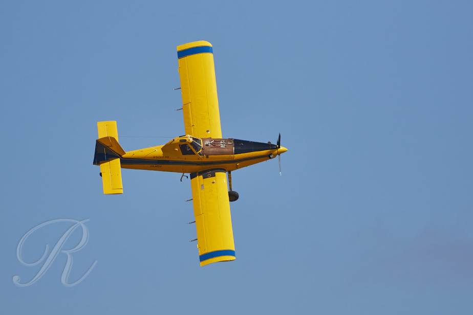
Life in the bush is quiet and peaceful.
Unless of course the neighbours have decided to spread fertiliser by the aerial route.
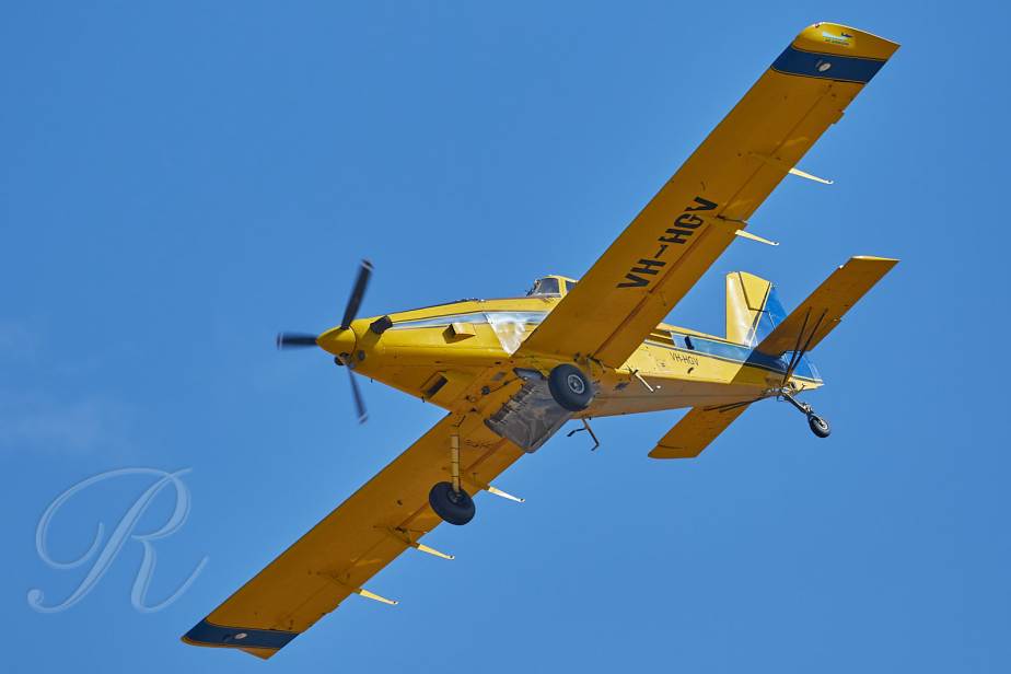
Hotel Golf Victor here was built by Air Tractor Inc in 1996. It is powered by a single Pratt & Whitney turboprop engine that makes an impressive amount of noise.
In the next photo you see it shedding its load. The wire beneath it is the electricity supply to my house!
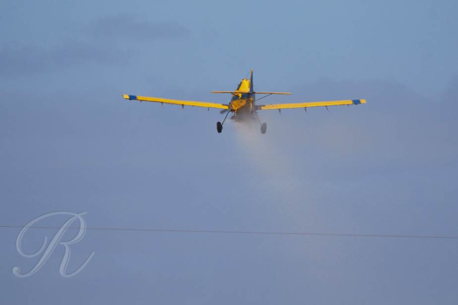
Little things like that and trees …
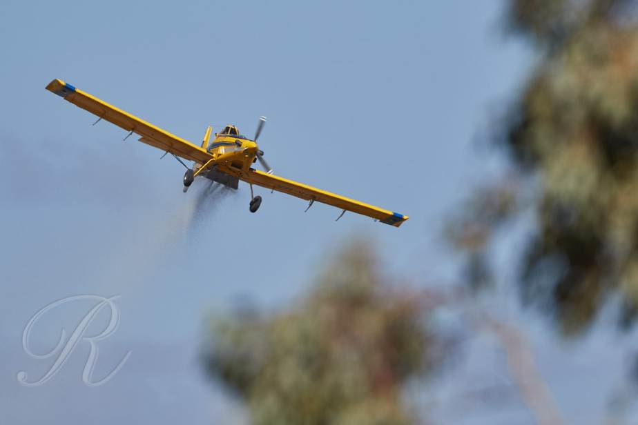
contribute to an accident rate about double that of the rest of General Aviation. My own personal air show, very impressive.