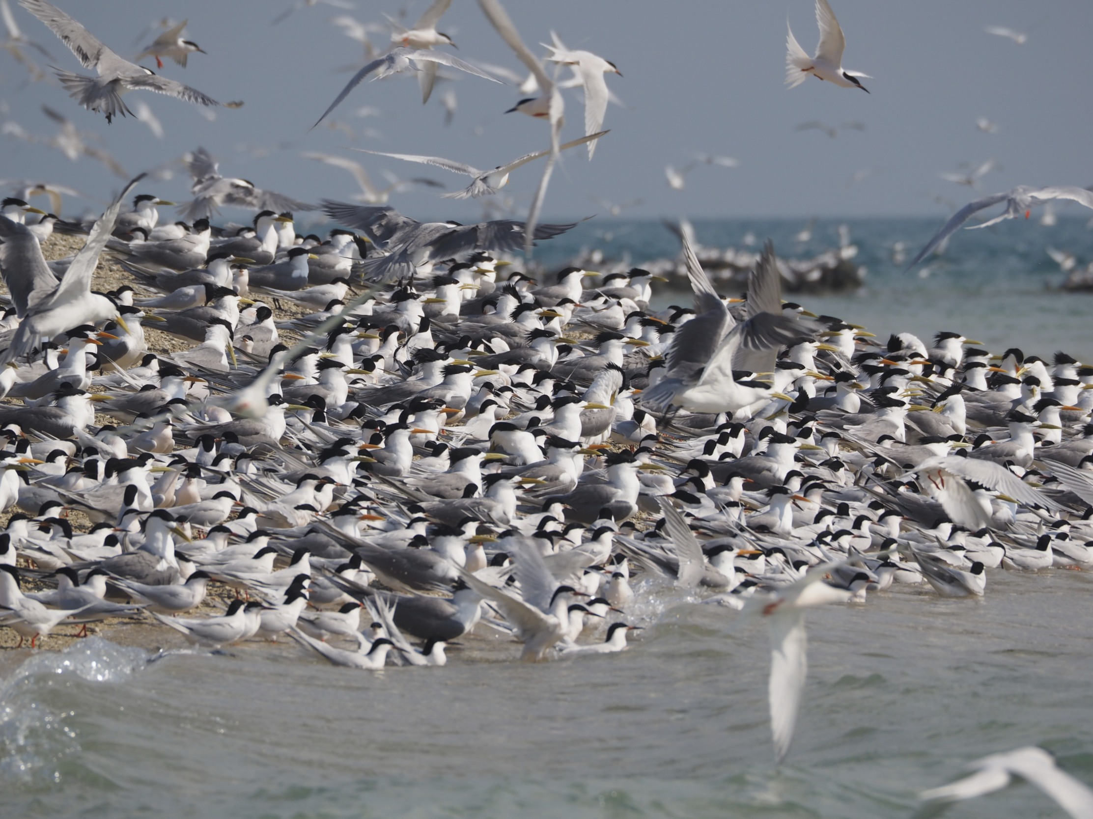
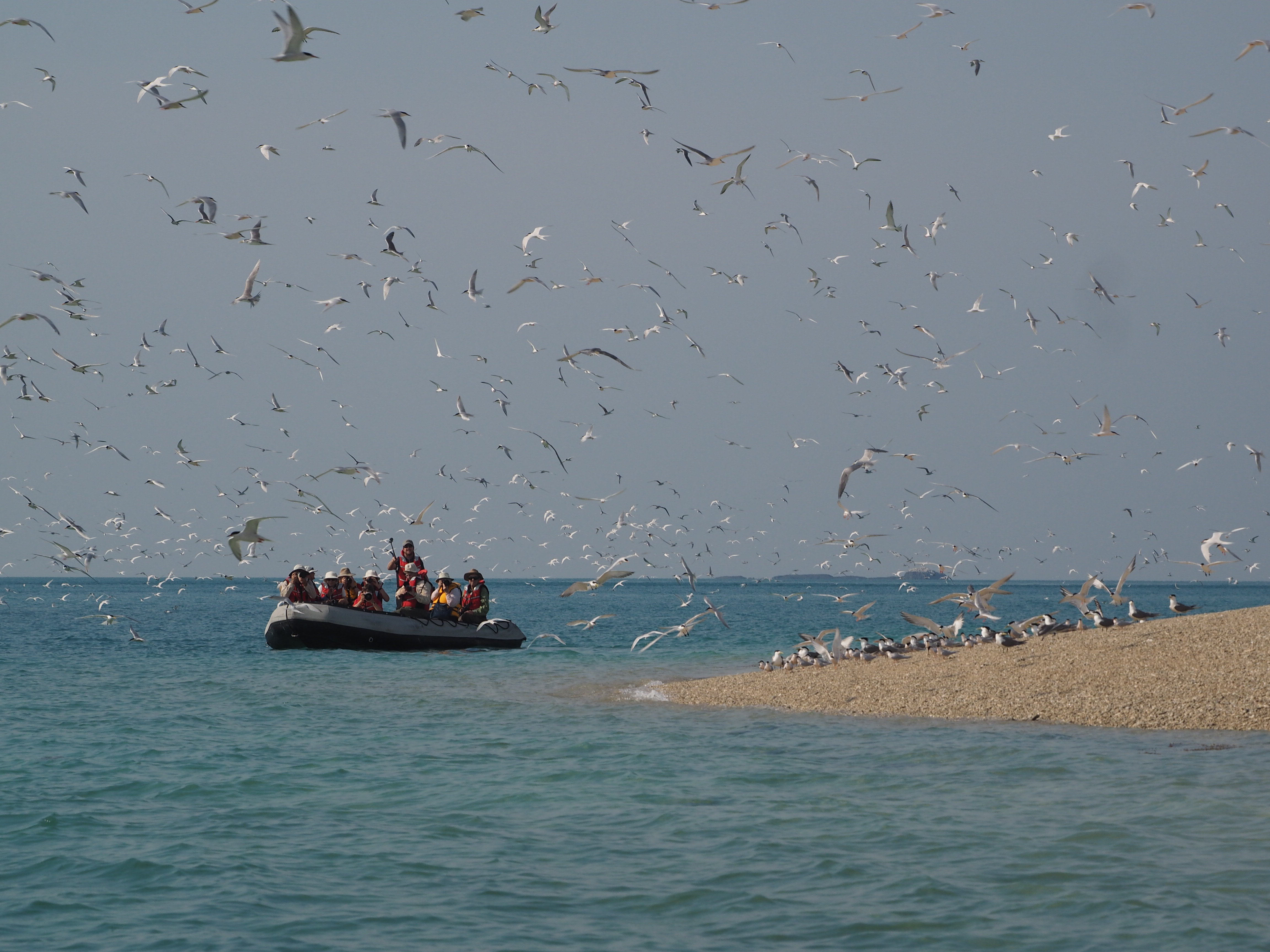
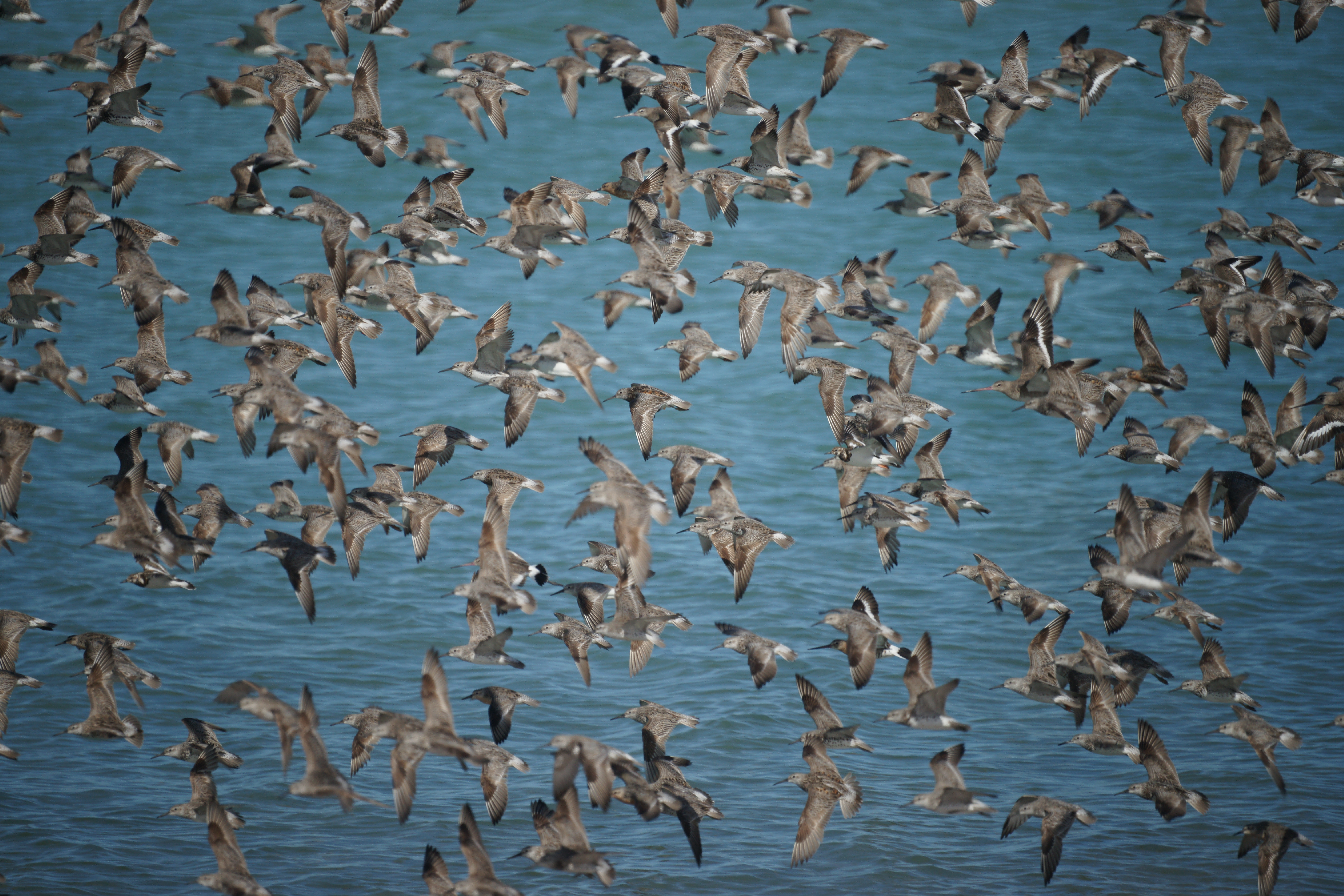
Not far from Bigge Island was, for me, one of the highlights of the Kimberley trip, Sterna Island. If you click on the photo it will fill your screen and you can try your diagnostic skills. There are three species of Tern to be found. If you find a fourth let me know. The back arrow in your browser brings you back to this page.
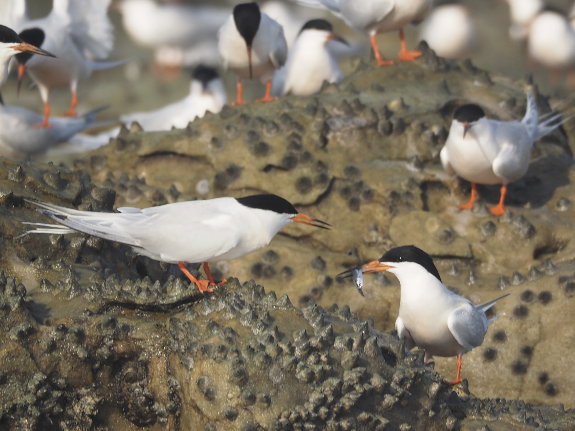
There were many thousands of breeding pairs of terns. Plus a pair of Peregrines that could have lunch whenever they wanted and one did before our very eyes. A White-bellied Sea Eagle also flew through causing a fair bit of mayhem. But it was mostly about the terns. The Roseate were in peak breeding plumage …
The presentation of a fish serves the same purpose as a rose on Valentines day.
The next photo shows Crested and Lesser Crested Terns in the one view. To tell them apart just remember the Crested has a bill the colour of Lemon peel, the Lesser Crested has a bill the colour of Orange peel …
Birds just bursting with energy. You have to click on this one …
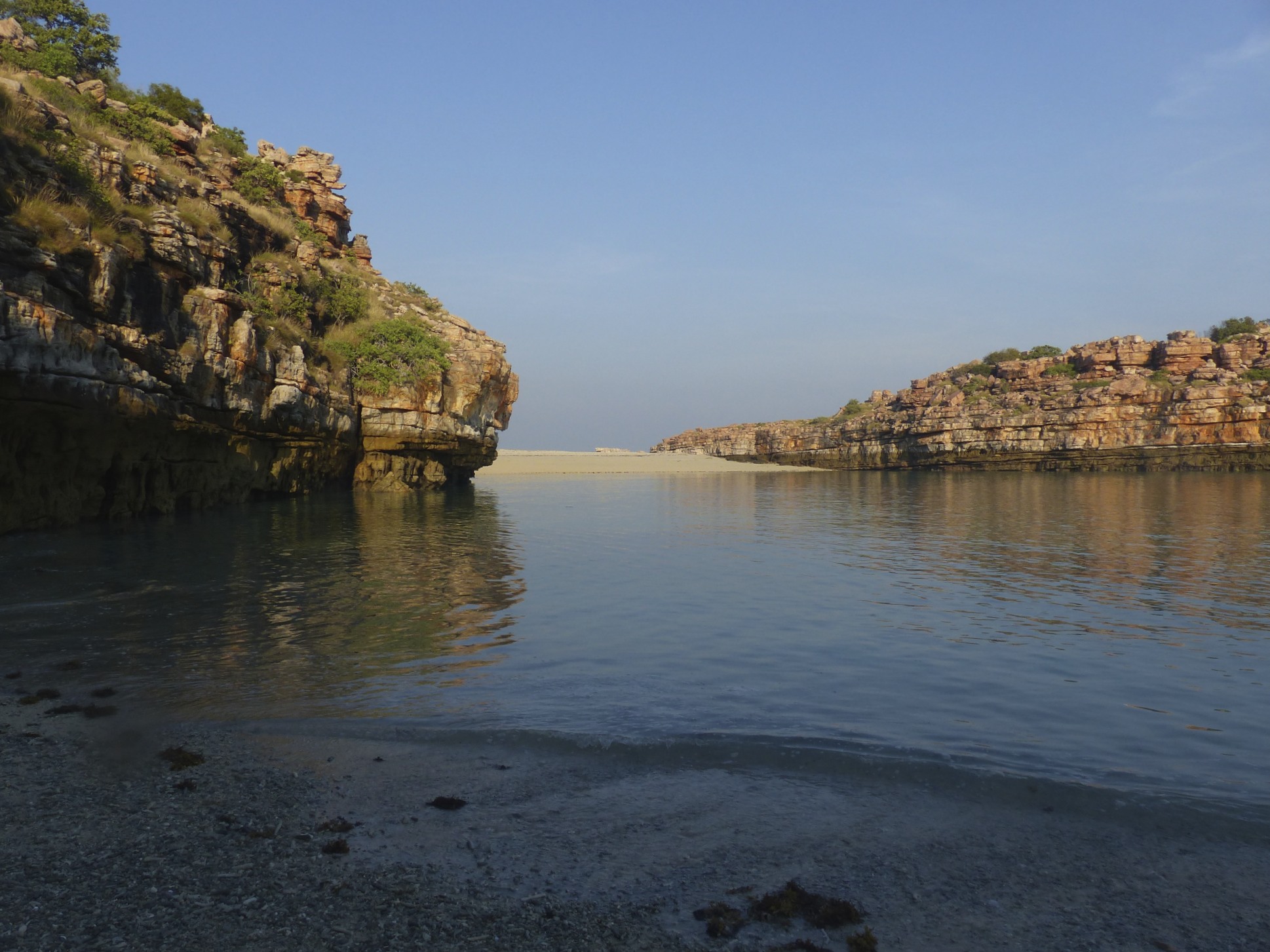
Another big day in the Kimberley. May 3rd started out with a boat trip past Crocodile Rock …
to a little cove …
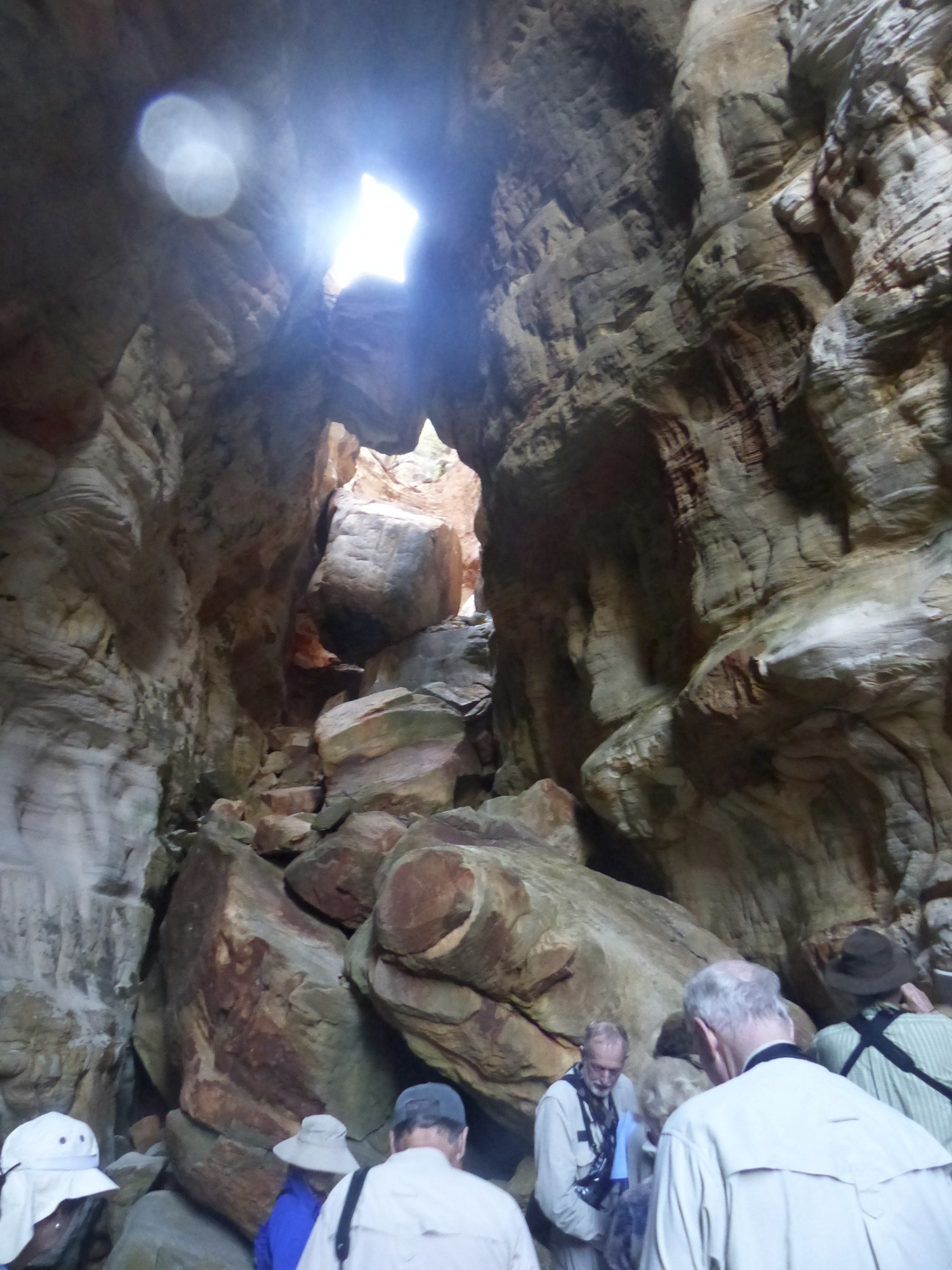
in which, at low tide, there is the entrance to a natural cavern …
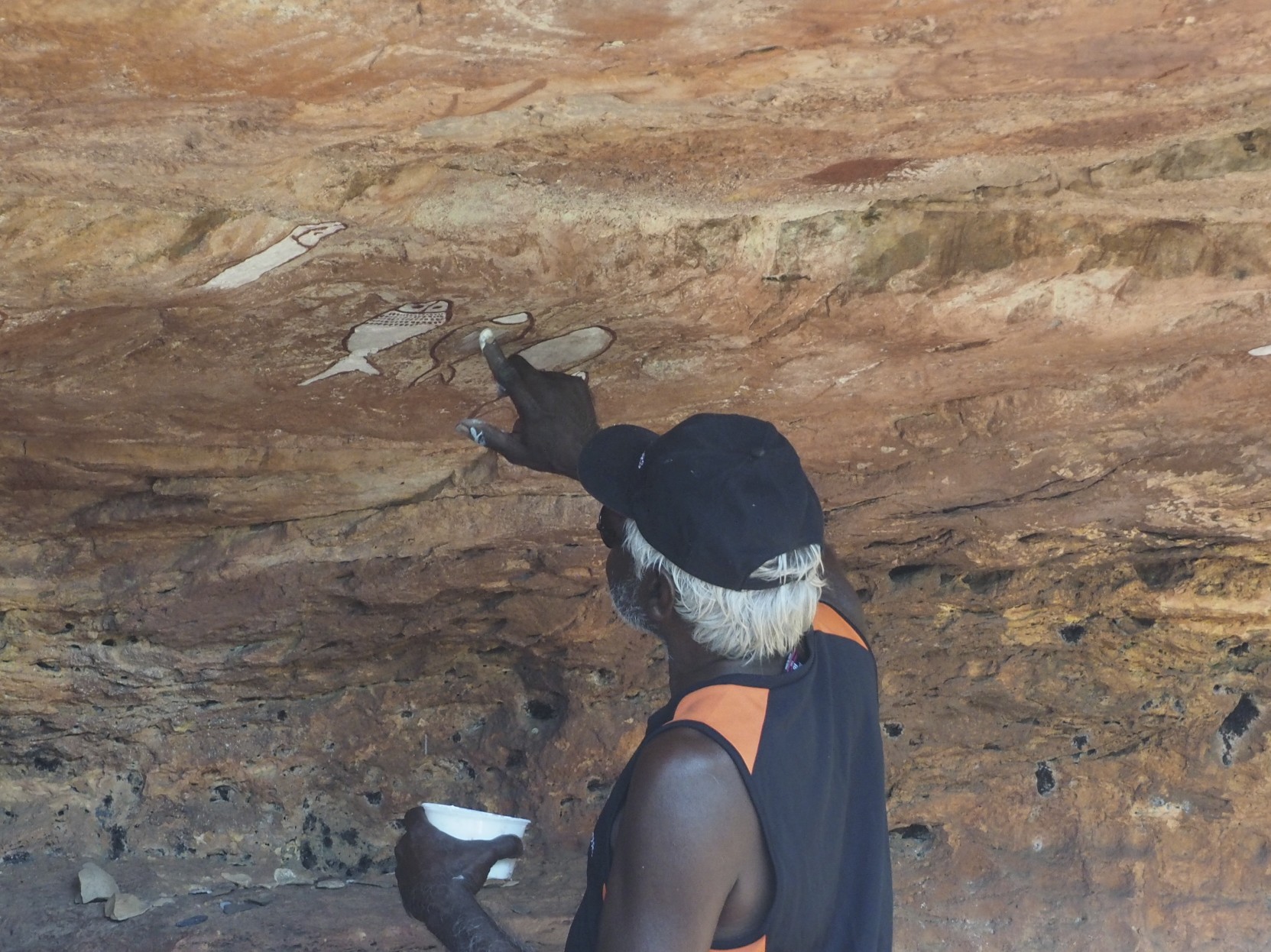
It was a day spent in the vicinity of Bigge Island, not a lot of other people around but a place of significance to people for probably some 65 000 years. Here is a ceremonial ground, a place where initiations and significant cultural activities would have occurred …
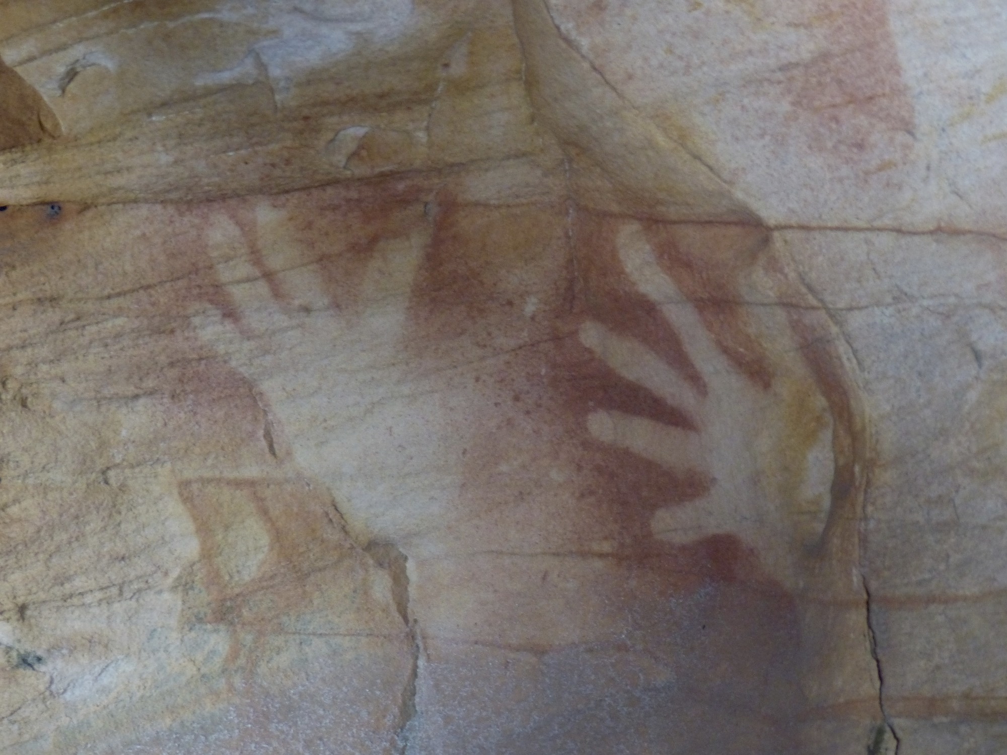
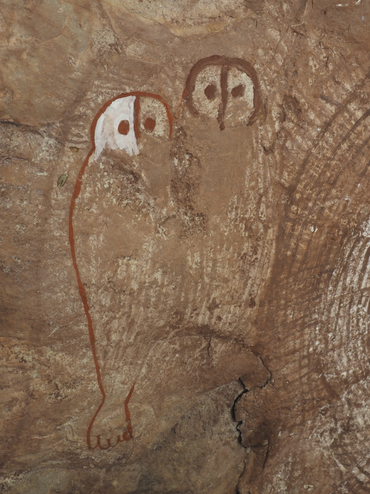
In that one day we were able to see three styles of rock painting. The Wandjina style is a living tradition, the most prominent theme is the Wandjina itself …
… but other dream time figures and animals are also depicted. Hands are popular.
These in-filled kangaroos are beneath an overhang that is not suitable for habitation and may be an example of an older style …
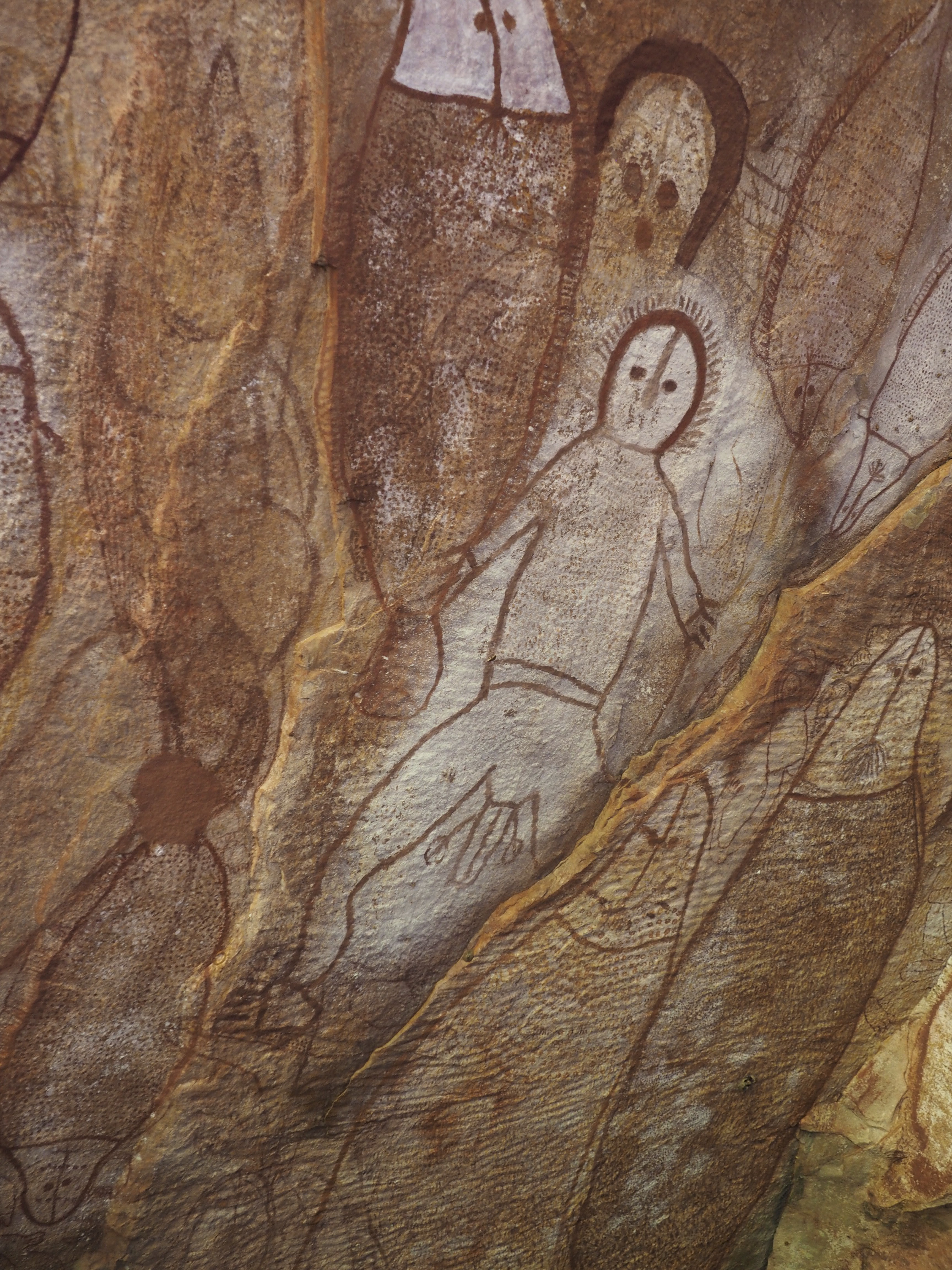
Most intriguing of all though are the Bradshaw figures. Not only are they elegant, they are shrouded in mystery and have an interesting recent history. There existence was made known to the European world by Joseph Bradshaw who discovered them in 1891 whilst searching for a suitable place to run some cattle. He was familiar with the Wandjina style and recognised these figures as something quite different.
He wasn’t carrying a camera and the exact location was hard to record. The pastoral enterprise came to nought and so when he later came to address the Victorian branch of the Royal Geographic Society all had to show was his sketches. His enthusiasm for the fine detail and an aesthetic worthy of ancient Egypt elicited a lukewarm response.
American archaeologist Daniel Sutherland Davidson in a survey of Australian rock art published in 1936 was dismissive, pointing out that Bradshaw’s encounter with this art was brief and lacked any Aboriginal interpretations, his sketches were likely inaccurate and drawn from a Eurocentric bias.
Bradshaw’s discovery didn’t reach the mainstream until the 1950’s. Rediscovery of his original gallery has shown his sketches to be remarkably accurate.
And what of the Aboriginal interpretations? When archeologists began to ask about the figures they found that the local people did not hold them in high regard, tastes had changed. They have explanations for the origin of the paintings but, unlike Wandjina art, no stories that bring them into the fabric of their lives.
The paintings mostly depict human silhouettes in a dynamic style that suggests running, hunting or dancing. They are often dressed in elaborate head ornamentation and often have tassels or sashes at the waist.
An enormous amount of research has been carried out by amateur archaeologist Grahame Walsh between 1977 and and his death in 2007. But for all that we know little about the people who made these ancient and evocative images and exactly when they were painted.
One of the first questions after the helicopter briefing was “Will we all get a window?” Clearly there was a concern that we might not get a good view. The answer, said with a smile, was “No, you don’t all get a window”.
In fact, you don’t all get a door. If you’re in the back the view is absolutely unimpeded. In the front you get a nice big window.
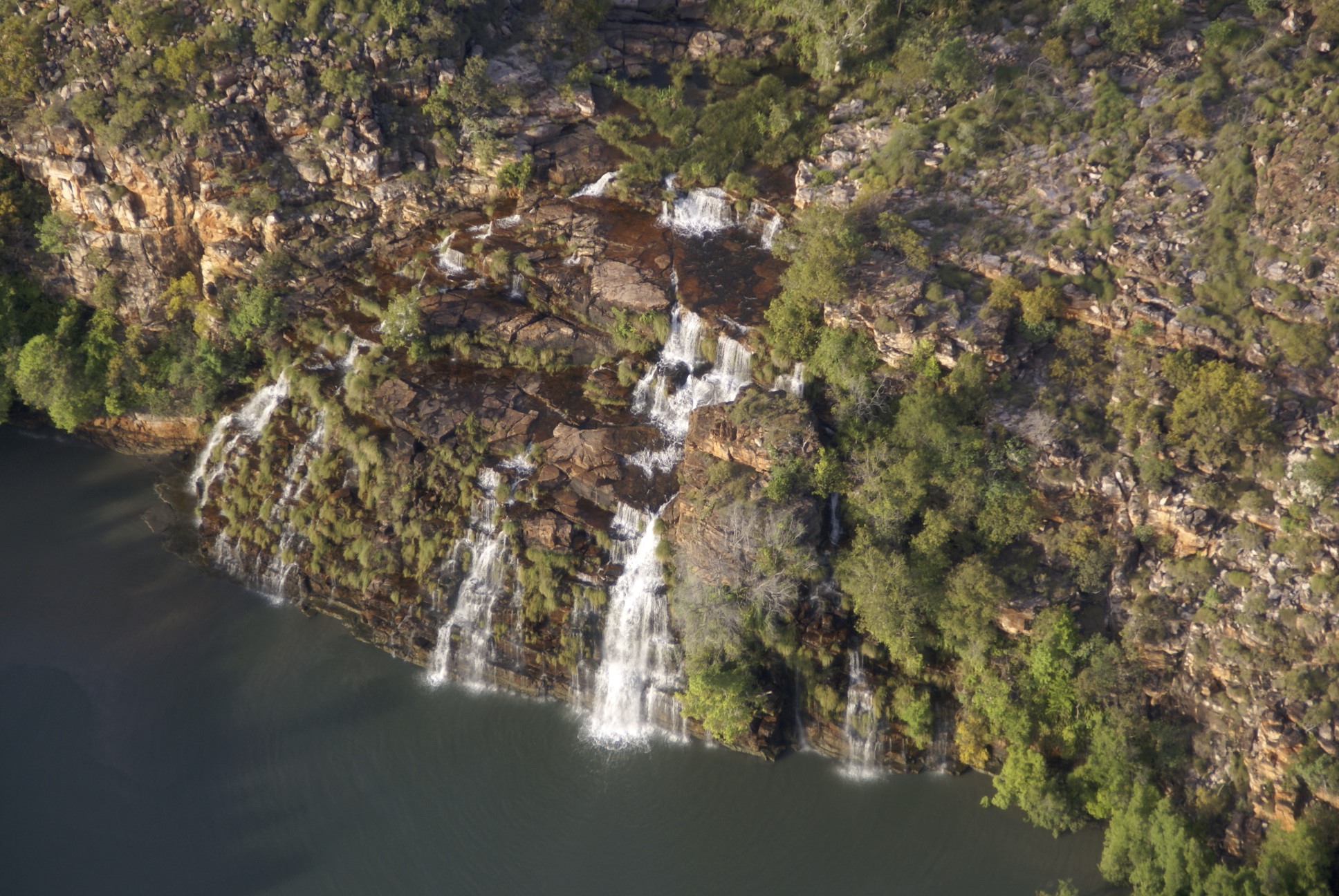
The ride took us from the beach up to the Mitchell Plateau to where the Mitchell River drops rather splendidly off the edge.
A short walk from the helipad brings you to this view.
In 1820 Phillip Parker King, exploring the Kimberley coast in the good ship Mermaid, came across the mouth of a river. He named it the Prince Regent River after the soon to be King George of Hanover and appropriately enough he named the bay it issues into Hanover Bay. King had been instructed to pay particular attention to any river that might provide a navigable route into the centre of Australia, there was still a strong belief at the time that there might be an inland sea or at least a Mississippi size river to be found. He also needed fresh water.
He recorded in his journal that as his men rowed up the river …
At a distance of 17 miles from St George’s Bank we were surprised by hearing the noise of a fall of water. But distrusting our ears we were not convinced of the fact until an opening in the mangroves exposed to our view a cascade of water 160 feet in breadth falling from a considerable height.
King continued up river until he was satisfied that it didn’t offer access to the inland and collected water on his way back to the Mermaid. The falls are now called the King Cascade.
In fact the river arises not that far away in the Caroline Range. The line of least resistance was a fault line and consequently the Prince Regent River runs a remarkably straight course. The few tributaries that it has, also following fault lines, run in at nice orderly right angles.
It is an idyllic place but do resist the temptation to have a swim at the foot of the falls, estuarine crocodiles are common in the river. In 1987 24-year-old American model Ginger Meadows was taken by a four-metre crocodile at this exact spot. And as we were hearing about this sad event we were watching this guy patrol the water behind the boat …
You can find some thought provoking information from WA Parks about crocodiles <HERE>.
If you know the tides well enough you can take a raft from Montgomery Reef and make it to Raft Point. Get it wrong and you will vanish without trace. We took a ship.
Welcome to the traditional home of the Worrorra people.
Two nightjars fought, blood was spilled. The blood of one was a light ochre in colour, the other darker and so today the Worrorra paint mainly with light and dark ochre. They are one of the groups that share the Wandjina tradition. In the dream time the Wandjina travelled the earth, altered its shape, lived, fought their battles and when it was time to die entered caves and left their images on the walls. It is the task of the modern folk to maintain the images.
This is Uncle Donny, the current custodian of the tradition, the only person qualified to paint the figures. It his task as well to instruct the younger men and one day he will choose his successor. It will be a great honour for the person chosen, and it will not only be for their painting skills but also their knowledge of the stories attached to each figure.
As well as the Wandjina figures, always painted without a mouth, there are other dreamtime characters such as the Lightning Man and images of food animals.
At the back of a nearby beach there is the site of a great Wandjina battle. The losing army was turned to stone and can be seen to this day.
The Poms began to arrive in Australia, to stay, in 1788. They were particularly concerned at that time about the intentions of the French regarding this newly available continent.
Naturally the early explorers were from Britain and Europe, the first generation of Australian Europeans had to be born and grow up for a while. Phillip Parker King was born in the penal colony on Norfolk Island in 1791. His father, Philip Gidley King was the commandant of the settlement and would later be the Governor of New South Wales. Young Phillip was sent back to England for his education and looked forward to a career in the Royal Navy.
In many respects his timing was abysmal. King entered the Navy in 1807, the war with France was at its height, he served with distinction and was commissioned lieutenant in 1814. The following year it was all over, Napoleon once a rooster was now a feather duster, Britain had an enormous navy and no one to fight. Naval officers were put out to grass.
Fortunately for young Phillip his talent for meticulous surveying and draughtsmanship had been noticed. He was sent out to Australia to fill in the gaps in the coastal charting. A number of Explorers had grazed the coast of Oz. Dampier and Cook perhaps the most famous and Mathew Flinders had completed the first circumnavigation by 1803 (although he was somewhat slow getting the results out due to his imprisonment in Mauritius on his way home … for six years. Those bloody French).
The notable gaps were the Kimberley coast, the northern reaches of the Great Barrier Reef and Bass Strait. Between 1817 and 1822 King meticulously filled in the gaps. And when he’d finished that he went to South America and sorted out the southern tip. He deserves to be right up there with Flinders but he is hardly known, a neglected native son.
Montgomery Reef was discovered by King in 1821 and named for the ship’s surgeon. It’s out in a bay about 22 km from the nearest point on the mainland. On a high tide you might pass right over it but as the tide falls it emerges and looks rather splendid.
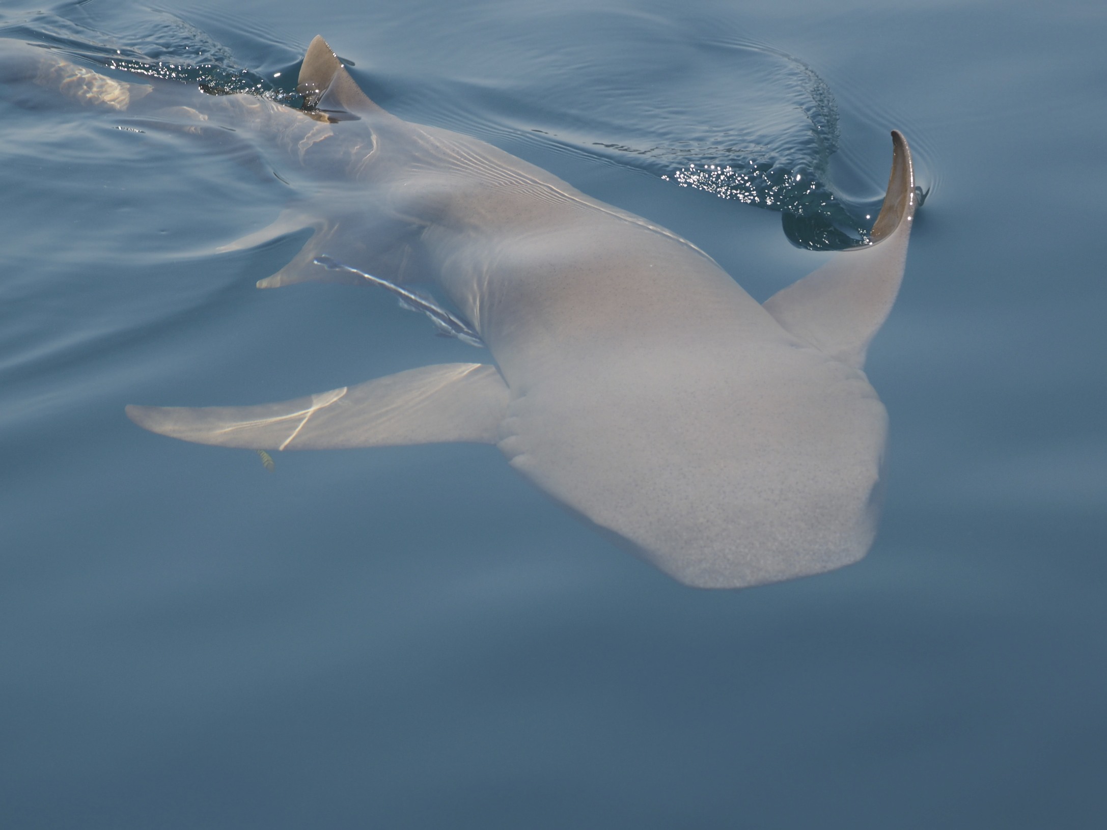
It’s home to turtles and sharks and at low tide numerous Eastern Reef Egrets and wading birds that have to make alternative arrangements when the water rushes back to cover it all again. The reef is about 80 km long and covers an area of about 400 km². Small sand islands, called the High Cliffy Islands, were home to the Jaudibaia people, excavations reveal their presence as long ago as 6,700 years. They spoke a distinct dialect. They are unique among Australian aboriginals in living on such small islands but fish and turtles were stranded on the adjacent reef twice a day and provided handsomely. The Jaudibaia were reputed to be of impressive stature many reaching 7 feet in height. A film crew for Pathe News visited in 1929 when they found about 300 people. The next time anyone thought to look there were none. No trace and no explanation.
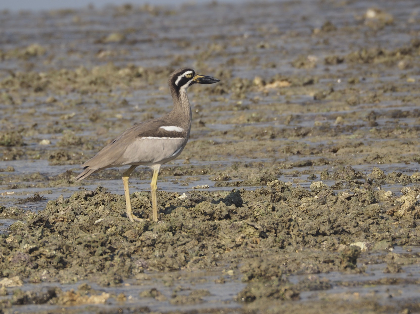
Our visit was graced by a flock of White-winged Terns in full breeding plumage, a stranded turtle and many in the water, close looks at Eastern Reef Egrets and other shore birds such as this Beach Stone-curlew …
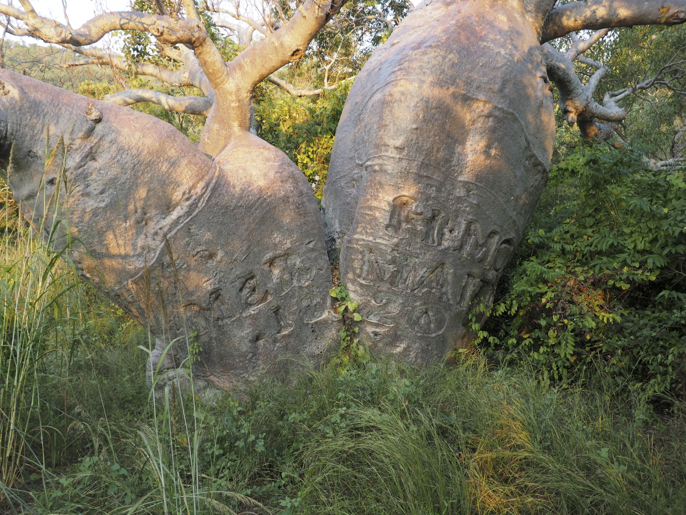
King’s ship was His Majesty’s Cutter Mermaid. It had been cobbled together with iron not copper nails. As time passed and the nails rusted out it began to leak furiously. During 1820 King selected a suitable beach with easy access to fresh water and careened her. The work took six weeks, numerous holes being plugged with locally cut wooden bungs. The Mermaid still leaked when she was refloated.
Whilst at Careening Bay a memento was carved in a Boab tree.
HMC Mermaid 1820
Admiral Phillip Parker King, FRS, RN died at his home in North Sydney on 26 February 1856.
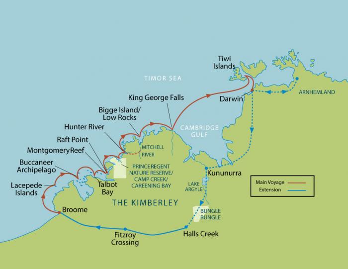
The cruise took us north from Broome, past the Lacepede Islands to the Buccaneer Archipelago and Talbot Bay.
The Buccaneer Archipelago consists of more than 800 islands and the vista is grand in every direction.
The tidal range is enormous in these waters, there may be as much as 8 metres between the height of high and low tide. Cyanobacteria colour the rocks in the intertidal zone so you can get a good idea from the next photo. This is the famous Horizontal Waterfall at slack water. As the tide changes the water pours through with such force that at peak flow there is a difference in height between the sea and the inner bay, it looks like a waterfall, but stick around, when the tide is roaring in the opposite direction what was falling in will be falling out.
A compromise title, I figured that the more obvious Geology of the Kimberley would get little attention in the blogosphere whilst Kimberley Gets Her Rocks Off might get the wrong sort.
The Kimberley that you see as you cruise past is what’s left by processes over eons. The time involved is almost unimaginable compared with a human lifespan and the processes seem extraordinary but they could not be more ordinary. It’s all a matter of some key events, time in abundance and weather.
The first key event happened two billion years ago when a little tectonic plate, the Kimberley Craton, smacked slowly into the North Australian Craton. The Kimberley Craton rode up over the other forming a mountain range that probably rivalled the modern European Alps in size. (Kimberley likes it on top).
Erosion commenced and the products were washed into the adjacent shallow seas forming sandstone which is up to 5km thick in places. Uplifting and the outpouring of basalt (especially in the Mitchell Plateau and Ord River region) followed by more erosion. Add a few volcanic injections of dolerite (especially the King Leopold Range). Take a great barrier reef and raise it well above modern sea-level as the Napier and Ningbing Ranges and all you need to do now is to add flora and fauna.
To summarise, on this cruise you will be seeing a lot of sandstone.
In the southern section it will be very impressive because it is folded. Further north it will be very impressive because it is not. It will be most impressive early and late in the day when the low sun falls on it.
FoldingTiltingBlock faulting
And where conditions are right the uppermost blocks can undergo further weathering to produce beehive like structures. This can be seen on a grand scale in the Bungle Bungles but also occurs on the coast …
If you are inclined to study this topic more thoroughly here are a couple of handy links …
I first visited Broome in 1996. I played a small part in an Australian Wader Studies Group expedition that caught and banded birds like these …
If you click on the picture it will fill your screen and you can test your diagnostic skills. The back arrow on your browser will return you here. (This is true of almost all the photos on this blog).
It’s a place that has a great magnetic pull. A couple of the guys on the expedition stayed on and made it their home. I have been back many times and usually stay with one of them.
Most of the waders nest in Siberia and come to Oz to escape the winter snow of their breeding grounds. Roebuck Bay is a key resource for enormous numbers of them. It is the premier site for shore birds in Australia.
William Dampier explored the northern coasts of Western Australia back in the 17th century. The bay is named for his ship. By the 1880’s the surrounding waters were being exploited for pearl shell. In 1883 John Forrest chose the site for a port town that would serve the pearlers as a base. He named the place after Sir Frederick Broome who was the Governor of WA at the time. Sir Fred was not much impressed to have his name associated with such a humble outpost.
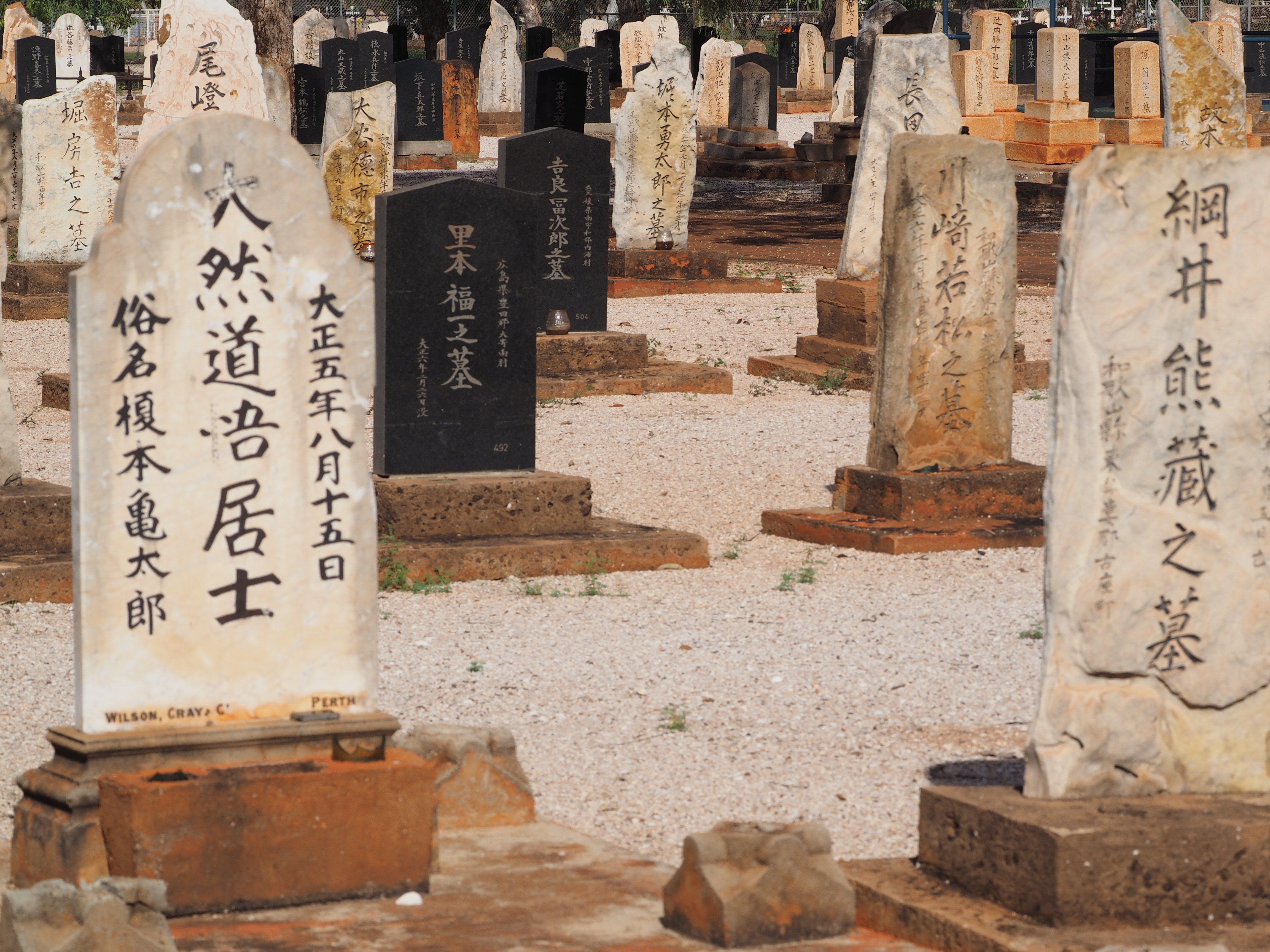
Quite an assortment of humanity worked in the pearling industry. The Japanese were especially prominent and there is a cemetery that provides a last resting place for many of their dead.
They also exerted their influence in the Second World War when they bombed the place four times killing 88 on one occasion.
The pearl industry is still important but has changed considerably. In past times it was all about pearl shell which was used extensively for buttons. Nowadays buttons are made of plastic and the industry makes its money out of pearls, mainly cultured.
Broome is the administrative centre for the Kimberley and is a base for the mining and gas extraction industries.
Above all, though, it’s a tourist destination. It boasts an international airport, an open air cinema, dinosaur footprints, camel rides, spectacular sunsets and a nude beach that extends some 17km from Cable Beach to, believe it or not, the mouth of Willie Creek.
This visit was part of a package with Zegrahm Expeditions so I got to stay at the Cable Beach Resort, such luxury. Nonetheless I played hookey the first day and went birding with my good friend Chris Hassell who is a professional ornithologist with Birdlife International and the Global Flyway Network.
A splendid day was had and at the end of it I was deposited at the port and embarked on the Oceanic Discoverer for a voyage to Darwin via the Kimberley coast.
Back in 2013 I made a 4WD trip to the Kimberley in search of the Black Grasswren. It was a splendid adventure which I described on my return.
The Kimberley is a remote and sparsely populated part of Western Australia. It is located entirely in the tropics. In summer it’s hot and wet, in winter it’s hot and dry.
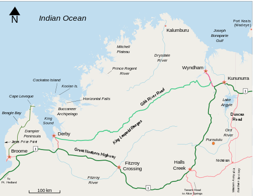
Here is the red bit in a little more detail …
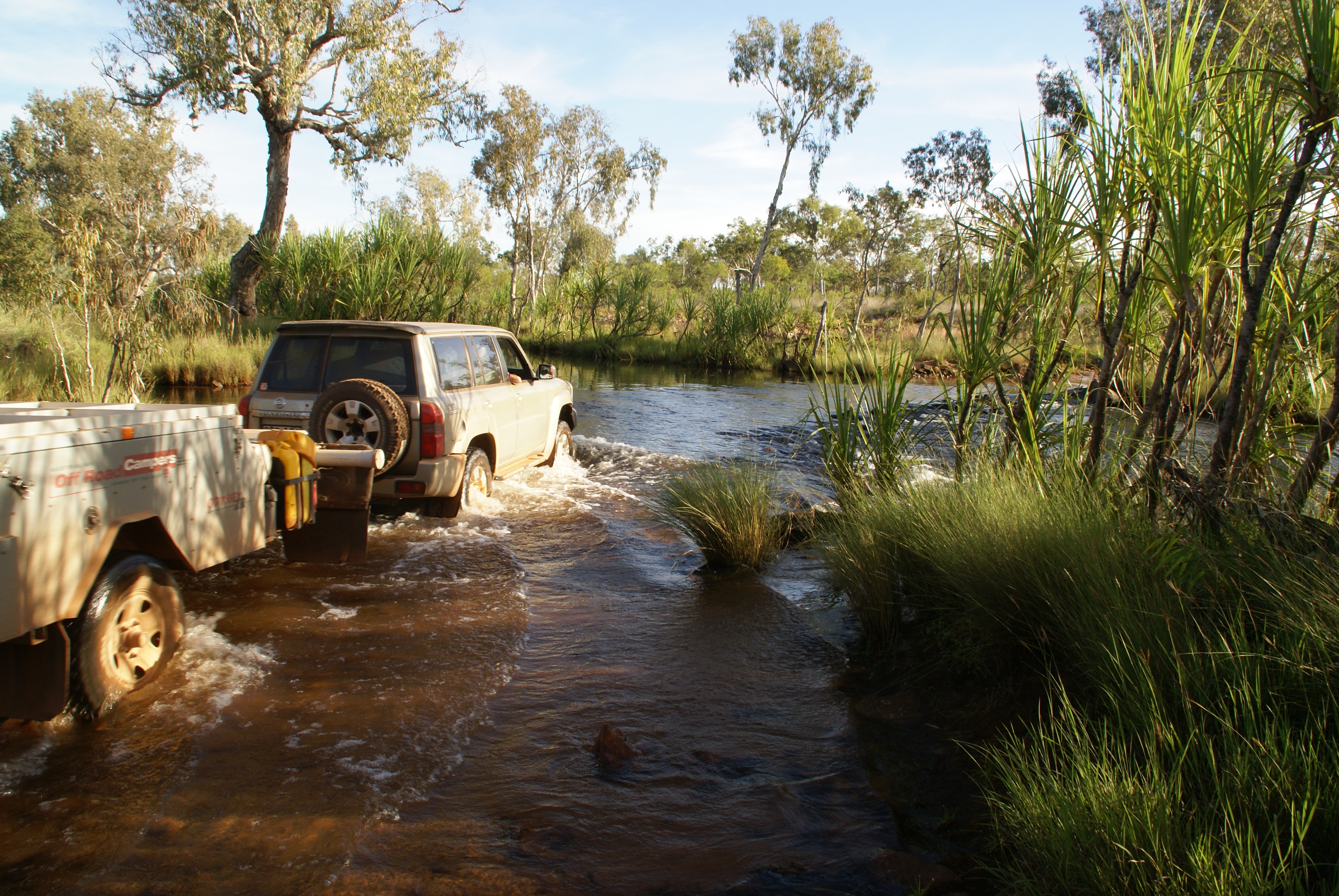
As you can see, between Derby and Wyndham the “main road” is always more than one hundred kilometres from the coast. The Gibb River Road is a modest expedition in itself but to really get to grips with the Kimberley you have to do battle with situations like this …
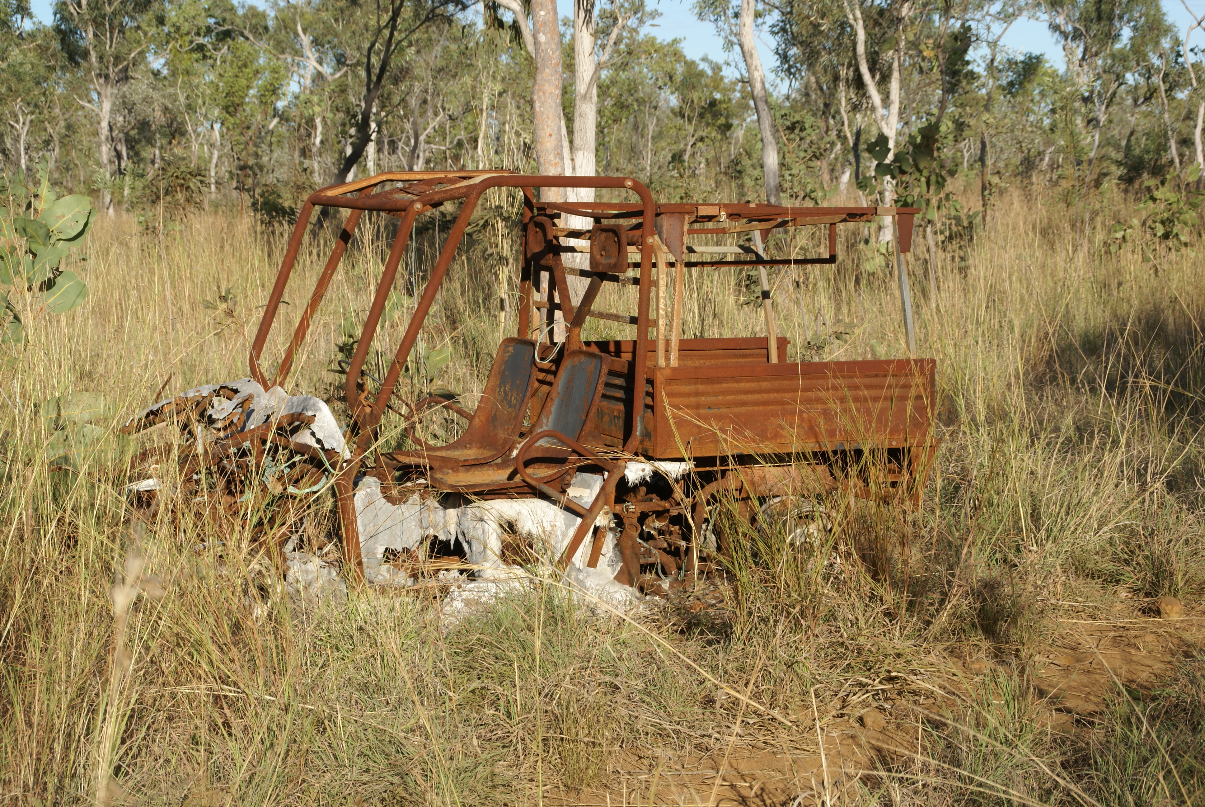
and from time to time you pass the skeletons of the vehicles that didn’t make it …
Your rewards are the bush, the waterfalls, the wildlife, the rock art and the exhilaration of getting out intact. All of which just makes you want to see more … and the way to do that is by ship.